On 9 October 2024, the second workshop in this year’s CIPU series built on the outcomes of the first workshop to further explore “The Climate-Resilient City”. Held in the city Dudelange, the workshop brought together 30 participants from Luxembourg’s municipalities and other stakeholders to explore strategies for enhancing urban resilience to climate change.

The workshop aimed to develop tools for municipalities for the development and adoption of climate resilience strategies. It continued discussions initiated in the previous CIPU workshop in June 2024 (see blog post here) and was closely tied to Luxembourg’s overarching efforts to integrate resilience into urban planning. Participants addressed the central question: “What can municipalities do to become more climate-resilient?”

As part of the CIPU’s mission, the event contributed to fostering exchange between municipalities and aligning local efforts with national and international frameworks. The workshop opened with a recap of insights from the first event and a presentation by Patricia Vilar from the Ministry of Internal Affairs Luxembourg. She provided an overview of national efforts to support municipal resilience, including the national platform for disaster risk reduction and the working group on resilient municipalities. Highlighting the importance of fostering collaboration and building networks, she connected local efforts with international frameworks such as the Sendai Framework for Disaster Risk Reduction.

Presentation by Patricia Vilar from the Ministry of Internal Affairs Luxembourg (source: Zeyen+Baumann)

With this inspiring input, the participants were then divided into four groups, each tasked with addressing three of four specific aspects of establishing a climate resilience strategy. Each group developed their own results, which were later aggregated into overarching trends and outcomes.

1) How can a climate resilience strategy be developed? Participants worked on outlining a framework for creating a municipal climate resilience strategy. Each group explored the essential steps, including initiating the process, collecting and analysing data, setting priorities, and planning implementation. A key outcome was a seven-phase process to guide municipalities: from defining responsibilities and gathering data to monitoring progress and involving stakeholders through communication and participation. The discussions highlighted that municipalities with prior experience in managing climate events could rely on existing data, while those less experienced needed to focus on risk assessment. Political commitment and sufficient funding were identified as critical to success, alongside a flexible and cyclical approach that allows for adjustments as circumstances evolve.

2) How should municipalities act during a crisis? Participants addressed municipal responses to two extreme weather scenarios (severe drought and heavy rain fall), focusing on three phases: preparation, response, and recovery. Key measures in the preparation phase included assessing local needs through surveys, developing emergency plans, and creating communication strategies. Specific actions involved identifying cooling zones for heatwaves and upgrading wastewater systems for heavy rainfall. During the response phase, the focus was on effective crisis management, such as issuing warnings, ensuring access to cooling centres or evacuation zones, and maintaining critical infrastructure. Temporary measures like water fountains or sandbags were also proposed. In the recovery phase, learning from events was prioritised, with measures such as enhancing cooling zones and adapting infrastructure to prevent future risks. The results highlighted that a structured, three-phase approach helps municipalities proactively address extreme weather impacts while strengthening long-term resilience.

Group work on how to develop a climate resilience strategy (source: Zeyen+Baumann)

3) How can urban areas adapt to specific climate risks? Participants addressed how to make an existing neighbourhood more resilient to the two fictive scenarios of a heatwave (2025) and heavy rainfall (2026). The discussions centred on three goals: creating resilient public spaces and infrastructure, ensuring resilient buildings, and protecting residents’ health and safety. Proposed measures for public spaces included identifying and enhancing “cool spots” through greening and reducing impermeable surfaces, while converting vulnerable “hot spots” into green or water-retention areas. Pathways between green spaces and neighbourhoods were prioritised to improve airflow and reduce heat. For buildings, the focus was on green roofs and facades, rainwater retention systems, and enhanced thermal insulation to mitigate heat and flood risks. Financial incentives and regulations were suggested to encourage private adoption of these measures. To protect health and safety, ideas included “heat plans” and “flood plans,” clear communication systems, and providing public cooling and evacuation centres. Participants also highlighted the need to balance resilience with urban density, noting that compact urban forms often increase vulnerability. Integrating resilience into early planning stages was deemed essential for long-term success.

4) What internal structures are needed to implement resilience strategies? Participants explored the organisational structures needed to integrate climate resilience strategies into municipal administrations. Groups developed models reflecting their size, resources, and specific climate risks. Two primary approaches emerged which can be adopted simultaneously:

  • Hierarchy-based structure: This approach included a central resilience coordinator and task force involving key departments, such as technical services, environment, urban planning, and communication. These departments collaborate to develop, implement, and monitor strategies, supported by specialised commissions or external advisors.
  • Risk-based structure: This flexible approach tailored responsibilities to the scale and type of climate risks. Smaller measures, like flood barriers, could be handled by individual departments, while larger initiatives, such as city-wide greening projects, required broader collaboration across multiple teams and governance levels.

Both models emphasised the importance of cross-departmental communication, adaptable structures, and, for smaller municipalities, inter-municipal cooperation to pool resources. Regular review and adaptation of the strategy were highlighted as essential to ensure continuous improvement and preparedness for future climate challenges.

Group work phase (source: Zeyen+Baumann)

The workshop concluded with a plenary session where participants shared their findings. Emphasis was placed on the cyclical nature of climate resilience planning, the need for robust data and stakeholder engagement, and the importance of integrating resilience into all stages of urban development. The participants developed a seven-phase approach as a structured framework to guide municipalities, covering steps from initiation and risk assessment to implementation, monitoring, and continuous communication. However, it was also noted that resilience planning must be flexible and adaptable to the size, structure, and resources of each municipality. Smaller municipalities may benefit from inter-municipal cooperation, while larger ones need clearly defined roles and cross-departmental collaboration.

Following the workshop sequence, the participants had the chance to visit Dudelange’s newly built multipurpose hall (Hall Polyvalent). Constructed with sustainable materials and designed for easy disassembly and relocation, the building exemplifies the principles of circular economy. It highlights how climate-resilient infrastructure can simultaneously support sustainability and urban adaptability.

If you are interested in a more detailed description of the workshop and the results of the group discussions, you can access the documentation here: https://cipu.lu/. The insights from this workshop informed the annual CIPU conference that took place on 18 November 2024 and will additionally be incorporated in a strategic statement on climate resilient cities synthesising the events and discussions from the CIPU year 2024. It is foreseen to be published beginning of 2025.

Contact

CIPU: cipu@zeyenbaumann.lu

References

Workshop documentation – available online (German): https://cipu.lu/

Differdange, the third biggest city of Luxembourg, is committed to becoming a climate-neutral city by 2030 as part of the EU’s NetZeroCities initiative. Key efforts include improving energy efficiency, increasing the use of renewable energy, promoting sustainable transport and reducing waste. Public engagement is central, with e.g. workshops involving citizens in policy-making.

Accueil - NetZero
Net Zero Déifferdeng 2030 (Source: https://netzero2030.lu/en/)

Aim

NetZeroCities is a platform supporting the European Union’s mission “100 Climate-Neutral and Smart Cities” and was launched as part of the Horizon Europe programme. It aims to achieve climate neutrality by 2030, bringing together 34 partners like city networks and research organisations from 13 countries. As part of this initiative, Differdange’s goal is to reach climate neutrality by reducing greenhouse gas emissions, improving energy efficiency, and expanding renewable energy use, while ensuring social and economic sustainability for its inhabitants.

This aim is driven by the growing need to address climate change, particularly in urban areas which are responsible for a significant portion of global carbon emissions and are the usually densely populated. Differdange’s involvement in NetZeroCities shows its commitment to leading climate action in Luxembourg and beyond, aiming to become a greener, more sustainable city that can inspire others across Europe.

Beginnings

In March 2023, Differdange signed the Climate City Contract, a governance instrument strengthening the city’s commitment to achieve climate neutrality by 2030 at all levels. This evolving document, shaped by input from local businesses, residents and environmental experts, serves as the city’s roadmap to a sustainable future.

The initiative addresses both local and global challenges – locally, by reducing air pollution, increasing energy efficiency and improving quality of life; and globally, by tackling climate change and reducing the city’s environmental footprint.

Activities

Differdange’s strategy to achieve climate neutrality by 2030 focuses on five key objectives, which are central to its Climate City Contract:

  1. Improving Energy Efficiency: The city prioritises the renovation of buildings to enhance energy efficiency, and aiming to reduce overall energy consumption.
  2. Achieving Energy Autonomy: Differdange is committed to increasing its energy self-sufficiency by expanding the use of renewable energy. While solar energy has been emphasized in some of the city’s broader plans, the main objective is to reduce dependence on external energy sources by enhancing local renewable energy production.
  3. Reducing emissions from transportation: To decrease emissions from transportation, Differdange aims to reduce individual car use by promoting sustainable mobility options.
  4. Reducing Waste: The NetZeroCities network encourages the implementation of measures that limit waste generation, contributing to the overall sustainability of its operations and ensuring resources are managed more efficiently.
  5. Offsetting CO₂ Emissions: For emissions that cannot be directly eliminated, Differdange is committed to compensating for its carbon output through local offset projects.

“NetZero is not just Differdange’s project, it’s everyone’s”: The city focuses on engaging its citizens in this transition. Through public workshops like “Energy savings in my household” and “Sorting, circular economy, and waste prevention”, inhabitants are invited to contribute to the co-creation of climate solutions. Community involvement is crucial to the success of such climate initiatives, ensuring that the transition is inclusive and reflects the needs of the population.

The first “City Tree” in Differdange (Source: https://differdange.lu/en/improving-the-air-naturally/)

One of several measures e.g. was the inauguration of the first “City Tree”, a moss filter installation in July 2024 on Place des Alliés. They do not only filter CO2, clean and humidify the air and thus improve air quality but also provide shade and seating.

Additionally, Differdange participates in the FUSILLI project which is funded by the EU’s Horizon 2020 programme and focuses on creating sustainable food systems. Over four years, the project supports 12 cities in developing sustainable, healthy, and inclusive food systems through open innovation Living Labs, empowering them to implement innovative actions across the entire food chain and sharing knowledge via an open community. These activities are aligned with the goals set out in the Climate City Contract under the NetZeroCities initiative.

Outlook

The NetZeroCities network provides valuable access to international expertise and resources, helping the participating cities navigate technical and financial challenges. Differdange’s commitment to achieving climate neutrality by 2030, as part of this initiative, is based on the objectives of improving energy efficiency, expanding renewable energy, promoting sustainable transport, and reducing waste. The city’s strategy is shaped not only by these technical measures but also by active citizen involvement, ensuring that the transition reflects the needs and priorities of its residents. Through public workshops e.g., Differdange is fostering a sense of shared responsibility in tackling climate change.

By maintaining this collaborative and inclusive approach, Differdange is positioning itself as a model for other cities in Luxembourg and across Europe, demonstrating that small urban centres can take action in achieving sustainability. Through these efforts, Differdange is not only reducing its environmental footprint but also setting an example of how cities can balance growth and environmental responsibility in the fight against climate change.

References

Ville de Differdange (English, French, German): https://differdange.lu/en/live/environment/projects/netzerocities/

Net Zero Déifferdeng 2030 (English): https://netzero2030.lu/en/

Inauguration of the first “City Tree” (English, French, German): https://differdange.lu/en/improving-the-air-naturally/

FUSILLI project (English): https://fusilli-project.eu/

Net Zero Cities (English): https://netzerocities.eu/

EU Mission: Climate-Neutral and Smart Cities: https://research-and-innovation.ec.europa.eu/funding/funding-opportunities/funding-programmes-and-open-calls/horizon-europe/eu-missions-horizon-europe/climate-neutral-and-smart-cities_en

This post was written by Marcela Mäder Furtado and Kirsti Hagemann


On June 10, 2024, the Cellule d’information pour la politique urbaine (CIPU) hosted its first workshop of the year, focusing on the crucial topic of climate-resilient urban development. The event took place at the Ellergronn Nature Reserve in Esch-sur-Alzette, where participants gathered to explore strategies that could help Luxembourg’s cities and municipalities adapt to the growing challenges posed by climate change.

The workshop commenced with a guided tour of the “Transition NOW” exhibition at the Ellergronn Nature Reserve. This exhibition highlighted how human activities affect the environment and the climate, underscoring the urgent need for cities to adapt to changing conditions. Following the tour, participants received a thematic introduction to key concepts such as resilience, climate resilience, and climate adaptation. Jeannot Behm, representing the city of Esch-sur-Alzette, presented the city’s ongoing activities related to climate change, resilience, and public awareness.

Guided tour through the exhibition Transition NOW at the Ellergronn Nature Reserve (Source: Ville d’Esch)

Following the introductory presentations, participants engaged in a collaborative group work phase that focused on key thematic areas related to climate-resilient urban development. Firstly, everyone moved through different groups to identify priorities and gather ideas across the four central themes: Urban and District Planning, Built Environment, Emergency Management and Crisis Communication, and Supply and Disposal Systems. These discussions were recorded on thematic posters to capture diverse perspectives and insights. In the subsequent phase, participants were divided into set groups, each focusing on one of the specific themes. They delved deeper into the identified priorities, discussing challenges, exploring potential solutions, and outlining concrete actions to enhance resilience in their respective areas.

Urban and District Planning: The discussions on urban and district planning focused on the importance of incorporating nature-based solutions to increase the resilience of cities. Participants explored the potential of the “sponge city” concept, which involves creating green spaces and water retention areas to manage stormwater and reduce urban heat islands. There was a strong emphasis on maintaining a balance between built environments and natural areas, implementing cooling strategies through tree planting and shaded public spaces, and promoting the “15-minute city” model to enhance local accessibility. Key messages included the need for comprehensive risk assessments, thoughtful urban design that prioritises sustainability, and the development of policies that encourage resilient urban planning practices.

Built Environment: In the group of the built environment, participants discussed strategies for designing and retrofitting buildings to withstand the impacts of climate change, such as heatwaves, heavy rainfall, and storms. The conversation highlighted the importance of using sustainable building materials and promoting low-tech, resource-efficient construction methods. Participants called for the development of clear legal frameworks and financial incentives to support climate-resilient architecture. Public sector building projects were seen as critical for demonstrating best practices and leading by example. The discussions concluded that a coordinated effort involving policymakers, architects, and builders is necessary to mainstream climate-resilient building practices.

Participants discussing priorities for climate resilience in urban and district planning (Source: Ville d’Esch)

Emergency Management and Crisis Communication: This group focused on the development of robust emergency management strategies and clear communication plans to ensure preparedness for extreme weather events. Participants stressed the importance of early warning systems, clearly defined action plans, and regular simulation exercises to enhance readiness. Community engagement emerged as a key theme, with discussions emphasising the need to educate the public about potential risks and appropriate responses. The session highlighted the necessity of strong coordination and the establishment of dedicated units composed of citizens and technical experts to oversee emergency management efforts.

Supply and Disposal Systems: The final group discussed sustainable approaches to managing water, energy, and waste in urban environments. Participants examined strategies for improving water quality, promoting water recycling, and implementing rainwater harvesting systems to reduce reliance on fresh water. The concept of the circular economy was central to discussions on waste management, with a focus on reusing materials and reducing overall waste production. The group also emphasised the importance of local renewable energy production and storage to ensure energy security and reduce carbon footprints. Key outcomes included the need for integrated planning that incorporates circular economy principles, local sourcing, and the exploitation of synergies between different urban systems.

Group work on identifying priorities for the different thematic fields (Source: Ville d’Esch)

After the vivid group discussions, the participants gathered in a final plenary session to reflect on the developed results. The guided tour through the exhibition “Transition Now” as well as the presentations emphasised the necessity of adapting urban spaces to the challenges imposed by climate change. The workshop highlighted the often-blurred lines between climate adaptation and climate resilience, revealing a need for clearer understanding and practical knowledge in these areas. Political support, resource allocation, public awareness, and effective collaboration among stakeholders were recognised as essential for the successful implementation of these strategies. Clear political and legal frameworks, both at the national and local level, were also deemed critical to support these efforts.

Building on these outcomes, the second CIPU workshop, which will take place on October 9, 2024, will focus on developing key elements of a climate resilience strategy at municipal level to strengthen Luxembourg’s urban areas. The goal is to identify starting points to actionable solutions that can be quickly implemented and contribute to long-term sustainable urban development, further sharpening the approaches discussed in this workshop.

If you are interested in a more detailed description of the workshop and the results of the group discussions, you can access the documentation here.

Contact

  • CIPU: cipu@zeyenbaumann.lu

References

The city of Esch-sur-Alzette has made a promising start as a leader in urban resilience, becoming the first city in Luxembourg to develop a resilience plan. Its objective is to enhance the city’s capacity to address a diverse range of challenges, including natural disasters such as floods and heatwaves, as well as technological disruptions such as cyberattacks and power outages.

Aerial view of Esch-sur-Alzette (Source: Ville d’Esch: https://administration.esch.lu/2023/01/27/esch-pionniere-presente-son-plan-de-resilience/)

Aim

The plan which was presented in January 2023 defines resilience as the ability of a system to withstand external shocks and maintain its essential functions, also applicable to a city. Therefore, the core objective of the Esch-sur-Alzette resilience plan is to guarantee the safety and well-being of its citizens during and after a crisis. By minimising potential damage and enabling a swift recovery after disruptive events, the plan fosters a more secure future for the city’s residents. In this objective, it defines measures to be taken and defines standards for the everyday work of the city of Esch.

Genesis and Composition

A dedicated working group, composed of representatives from five technical departments – IT Department, Industrial Services, Environmental Services, Municipal Works and Urban Development – initiated the creation of the resilience plan. Representatives from this working group now form the Operational Resilience Committee (“Comité de résilience operationnelle”), which is responsible for its coordination. This collaborative approach ensured a comprehensive perspective and the inclusion of expertise from various sectors.

The plan itself draws inspiration from good practices observed and exchanged about with other European actors proactive in the field of resilience. Cities like Rotterdam in the Netherlands and Vejle in Denmark, renowned for their approaches to crisis management, served as valuable models for Esch-sur-Alzette.

Urban resilience (created with ChatGPT)

Activities

The Esch-sur-Alzette resilience strategy adopts a layered approach akin to an onion, focusing on fortifying the city’s resilience from its core outwards. This entails securing the reliability of technical services on the inside, strengthening citizen-facing services and ultimately prioritising the well-being of both residents and businesses. The plan is built around 12 concrete actions strategically divided into three phases: before, during, and after a crisis.

Before the Crisis: Proactive Preparation. Each city department will assess its vulnerabilities and craft departmental crisis plans. These measures will involve updating safety protocols for critical infrastructure and implementing early warning systems to anticipate potential crises.

During the Crisis: Effective Response. Measures include pre-allocated budgets for crisis response activities, efficient damage assessment protocols, and documented departmental actions to ensure basic functionality and public safety. Additionally, backup plans as well as external and internal resource mobilisation strategies shall ensure a robust response even in unforeseen circumstances.

After the Crisis: Learning and Rebuilding. Regular training exercises and post-crisis debriefings will equip city departments to continuously improve their response capabilities. A structured approach to evaluating incidents will identify valuable lessons learned. Finally, Esch-sur-Alzette fosters a collaborative approach by sharing knowledge and best practices with partner cities, strengthening regional resilience. The plan is to proceed in seven steps. This includes the appointment of a “Chief Resilience Officer”, the regular discussion of resilience plans in the individual community services, the creation of Smart City use cases of technological solutions for increased resilience and the sharing of the plan with the member municipalities of the syndicate ProSud.

Resilience Matrix (Source: Ville d’Esch: https://administration.esch.lu/2023/01/27/esch-pionniere-presente-son-plan-de-resilience/)

Outlook

As a living document, the Esch-sur-Alzette resilience plan will continuously evolve to meet future challenges. The city plans to share its insights and experiences with neighbouring municipalities to foster synergies in resilience-building efforts. Furthermore, ongoing initiatives such as Smart City projects will leverage cutting-edge technologies to further enhance the city’s resilience. This pioneering initiative positions Esch-sur-Alzette as a model for urban resilience, proactively building a more secure and sustainable future for its citizens and potentially inspiring other Luxembourgish municipalities.

Contact

Ville d’Esch – Urban Development Division: https://administration.esch.lu/intro-et-contact/

References

Communication of the city of Esch (French): https://administration.esch.lu/2023/01/27/esch-pionniere-presente-son-plan-de-resilience/

Presentation of the resilience plan (French): https://esch.lu/wp-content/uploads/2023/01/Presentation-Plan-de-resilience-Ville-dEsch.pdf

Newspaper article in tageblatt.lu (German): https://www.tageblatt.lu/headlines/velodukt-gratis-kurzzeitparkplaetze-und-ein-resilienzplan/

In October 2020, a significant milestone was achieved in the southern Luxembourg region, as 11 municipalities under the PRO-SUD syndicate joined the UNESCO Biosphere network, a label renowned as educational hubs for sustainable development. This move accelerates a series of initiatives aimed at actively fostering sustainable development.

One of the key initiatives that followed was the collaborative formulation of a “territorial vision” for the region, harmonised with the objectives outlined in the Luxembourgish National Territorial Development Plan (PDAT). The “territorial vision” strategy is taking shape with the Mission Zero Carbon – 11 municipalities for the ecological transition launched in April 2023 and marked by the signing of a Letter of Intent by PRO-SUD’s 11 municipalities, the Minister of Spatial Planning, and the Minister of Environment.

Aim

The primary goal of Mission Zero Carbone is to foster regional collaboration towards achieving carbon neutrality by 2050, in alignment with the Luxembourgish national territorial development plan (PDAT). To realize this ambition, a range of strategies has been identified, encompassing:

  • Reducing energy consumption: Advocating for energy-saving practices and technologies across public sectors.
  • Increasing renewable energy usage: Promoting the adoption and integration of renewable energy sources, such as solar panels.
  • Enhancing energy efficiency through regional energy planning.
  • Promoting sustainable mobility: Advocating for active transportation modes like cycling and walking and enhancing public transport infrastructure.
  • Safeguarding and restoring natural habitats: Ensuring the preservation of existing ecosystems and rejuvenating degraded areas to amplify their carbon sequestration potential.
  • Educational programs engage students, teachers, and cultural associations in the ecological transition, fostering active participation and awareness to drive sustainable change.

A first concrete project of this regional approach is the bioclimatic map launched in partnership with the Luxembourg Institute of Sciences and Technology (LIST) and Geonet by acquiring vital data and conducting precise analyses on the urban bio-climate of the region.

Concurrently, the Bioclimatic Mapping Project is committed to assessing the urban bio-climate in the southern Luxembourg region. The recommendations derived from this mapping effort will be closely associated with PRO-SUD’s involvement in the Cool Neighbourhood Interreg Northwest programme, which is designed to address urban heat challenges. This initiative marks a significant advancement in fostering the development of sustainable and resilient cities through meticulous data collection and analysis. The results will be publicly available towards the end of 2024.

The localisation of the UNESCO Minett Biosphere (Source: https://minett-biosphere.com/en/our-biosphere/)

Genesis and Composition

After the Luxembourg UNESCO Commission began discussing the first biosphere reserve in the Grand-Duchy in 2016 and followed by 4 years of multidisciplinary work to complete the application, the Minett region was officially recognized as such in October 2020, making Luxembourg part of the scientific Man and the Biosphere (MAB) programme. This programme promotes the conservation of biodiversity by engaging inhabitants, educating, researching, and supporting regional initiatives for sustainable development. The Minett Biosphere presents a fascinating juxtaposition: abandoned mines transformed into biodiversity havens, alongside ongoing human activity within dedicated transition zones. The Minett biosphere encompasses a region significantly impacted by iron ore extraction, leaving behind a distinct industrial legacy evident in its topography and cultural heritage.

PRO-SUD coordinated the application process and organized citizen consultations. Founded in 2003, the syndicate is a regional development union comprising 11 municipalities in southern Luxembourg. PRO-SUD, with the support of the Spatial Planning Department, is committed to promoting sustainable development in the region through various projects encompassing economic development, environmental protection, and social well-being.

Activities

The Minett UNESCO Biosphere advocates for biodiversity conservation and sustainable development, engaging citizens in educational efforts and research. It offers logistical assistance to projects focused on environmental education, multidisciplinary, regional and cross border collaboration with a commitment to fostering socio-culturally and environmentally sustainable economic and human development.

The post-industrial landscape of the region highlights the potential for ecological resilience, with diverse flora and fauna now flourishing in former mining sites. However, managing the delicate balance between environmental protection and ongoing growing human activity remains a huge challenge. To address this, the biosphere employs a strategic zoning system comprised of:

  • Core areas (zone centrale): Dedicated to research and conservation, strictly limiting human intervention.
  • Buffer zones (zone tampon): Surrounding core areas, these zones aim to minimize the impact of human activities.
  • Transition areas (zone de transition): Allow responsible human activities like agriculture and development.
The territory of the UNESCO Minett Biosphere (Source: https://minett-biosphere.com/en/our-biosphere/)

The territorial vision delineates a comprehensive developmental blueprint for the Minett region, encapsulating six pivotal objectives to ensure project alignment with overarching sustainable development objectives:

  1. Sustainable development: Pursuing a holistic approach that integrates environmental, economic, and social dimensions.
  2. Territorial cohesion: Mitigating socio-economic disparities across the region.
  3. Attractiveness and vibrancy: Augmenting the quality of life of residents and businesses.
  4. Ecological transition: Attaining climate neutrality and safeguarding biodiversity.
  5. Governance and participation: Advocating for participatory decision-making processes and citizen involvement.
  6. Resilience and adaptability: Anticipating and preparing for future challenges to ensure sustained regional viability.

The collaborative initiative, Mission Zero Carbone, epitomizes this vision, rallying the 11 municipalities within the Minett Biosphere towards achieving regional carbon neutrality by 2050. Each municipality formulates its action plan in alignment with the mission’s overarching objectives, addressing localized challenges and opportunities. Collaborative endeavours facilitate knowledge exchange, resource consolidation, and joint implementation of impactful projects across the region.

An initial project under this framework is the Bioclimatic Mapping initiative, generating pivotal data and analyses on the urban bio-climate of the Minett Biosphere. Initiated in response to a municipality architect’s request for more precise bioclimatic data to inform sustainable urban development strategies, this mapping project employs climate scenarios—specifically the RCP4.5 scenario—to project climatic conditions. Utilizing the 25th and 75th percentiles of temperature distribution (17.5°C and 19.5°C, respectively) instead of mean values, it offers a nuanced understanding of potential climate impacts.

PRO-SUD has commissioned the Luxembourg Institute of Science and Technology (LIST) to spearhead this project, leveraging diverse methodologies such as remote sensing, on-site measurements, and citizen science initiatives over an 18-month duration until the project’s conclusion in late 2024. The resultant data will inform the development of a comprehensive climate model for the region, guiding decision-makers in formulating effective emissions reduction strategies.

Outlook

Mission Zero Carbone represents a significant challenge, yet it is pivotal for the Minett Biosphere to attain its climate goals and contribute to the Territorial Vision.  he Bioclimatic Map, furnishing invaluable data and analysis, plays a crucial role in guiding strategic actions and ensuring the first mission’s success to develop regional collaboration between the 11 municipalities. For those interested in the UNESCO Biosphere in southern Luxembourg, the website provides insights into its initiatives for achieving climate neutrality and other impactful projects. Further information can be found on the Minett Biosphere’s website.

Contact

Gaëlle Tavernier: prosud@prosud.lu

References

Minett Biosphere: (English, French and German): https://minett-biosphere.com/en/

Mission Zero Carbone: (English): https://minett-biosphere.com/en/news/mission-zero-carbone-kick-off-meeting-3/

Vision territorial (French): https://minett-biosphere.com/lu/projects/vision-territoriale-3/

Project ClimProSud (English and French): https://www.list.lu/fr/recherche/projet/climprosud/?no_cache=1&tx_listprojects_listprojectdisplay%5Barchive%5D=&cHash=ac5bde4a60223253a34e3f5ad42ffb87 Analysing the Urban Bioclimate of the South (Project ClimProSud (English, French, German, Luxembourgish): https://minett-biosphere.com/en/news/analysing-the-urban-bioclimate-of-the-south/

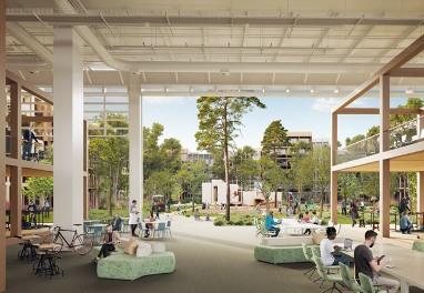
Introducing Kuebebierg, a new urban development in Luxembourg’s Kirchberg area managed by the Fonds Kirchberg, focused on creating a sustainable and inclusive community. With an emphasis on environmental responsibility, social diversity, and economic viability, Kuebebierg aims to set a benchmark for future urban projects. From promoting alternative transportation to supporting local agriculture, Kuebebierg offers a balanced approach to urban living that prioritizes harmony with nature.

Aim

The aim of the Kuebebierg project is to create a vibrant, environmentally conscious neighbourhood that promotes sustainable living, social inclusivity, and economic vitality. Through careful planning and implementation, the project seeks to establish Kuebebierg as a model for future urban developments, both locally and internationally.

Aerial view of the planned neighbourhood (Source: Güller Güller Architecture Urbanism)

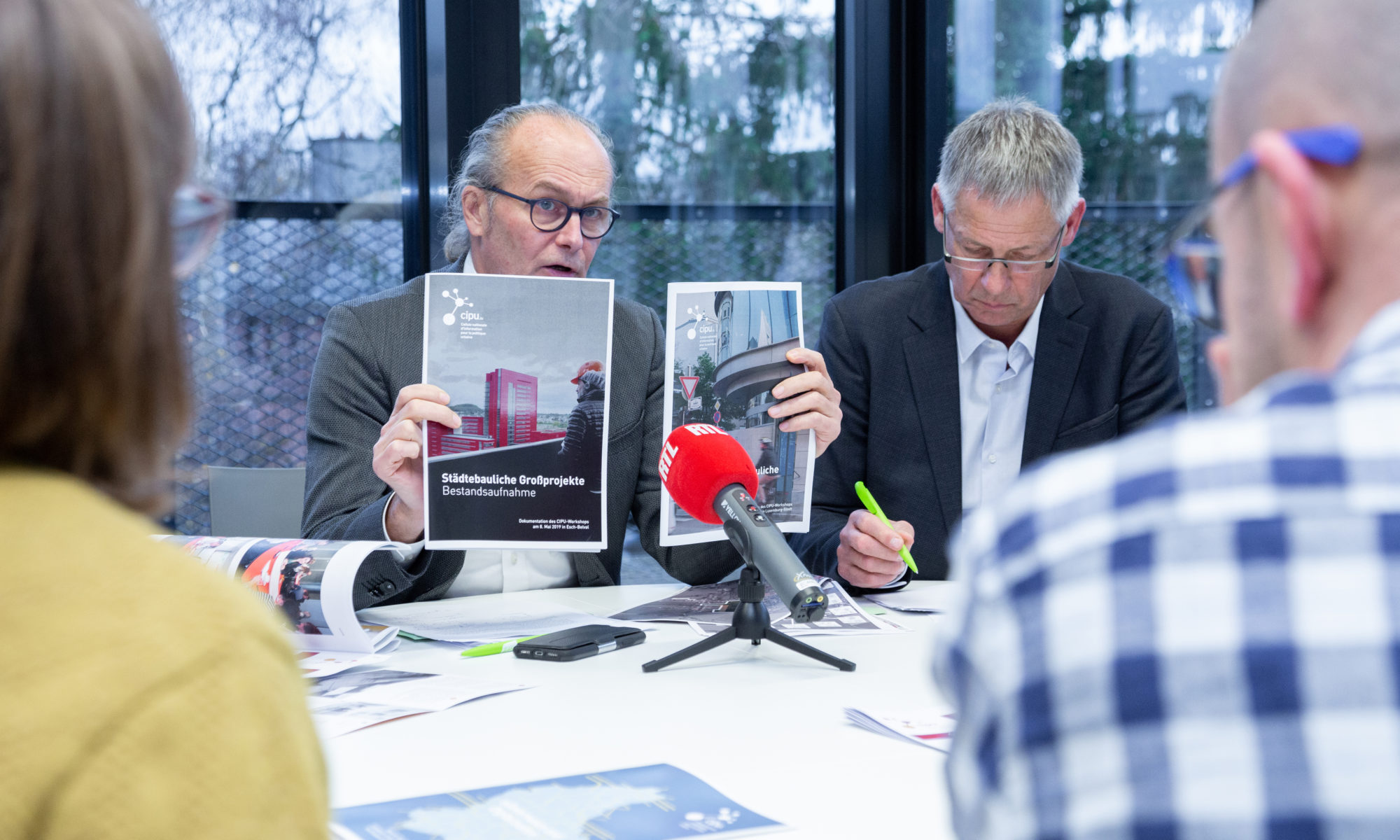
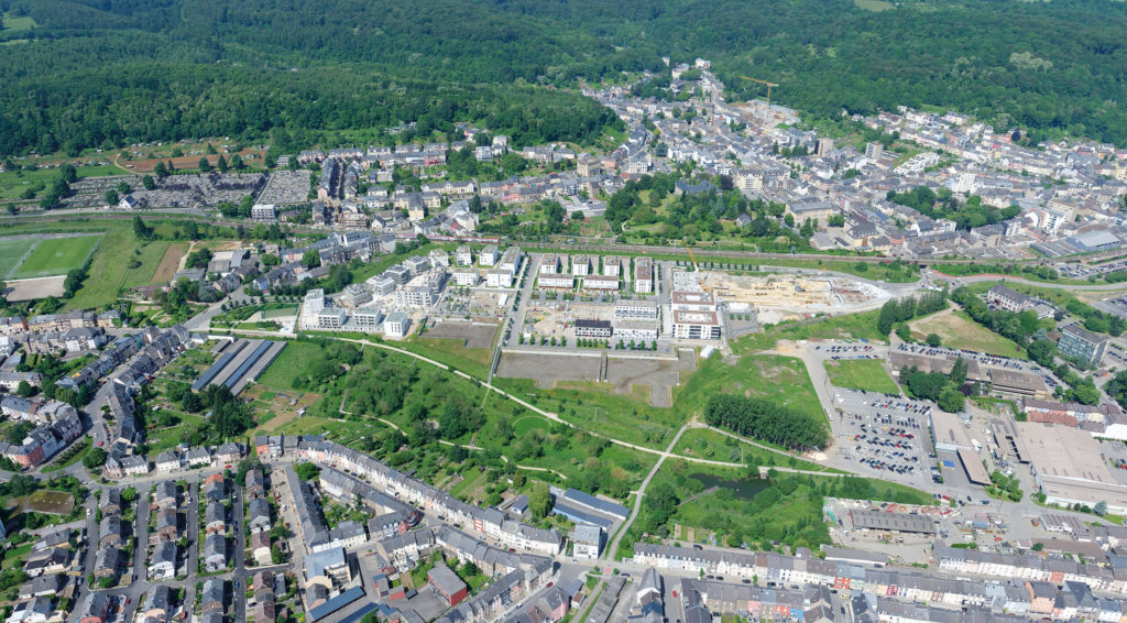
The Kirchberg quarter located on the north-eastern plateau of Luxembourg city is the vibrant business district, hosting not only banking and financial organisations but also EU institutions. The Fonds Kirchberg, established in 1961, operates under the supervision of the Minister of Mobility and Public Works and is responsible for urbanisation and development of the Kirchberg Plateau. It manages its operations and investments independently, relying on proceeds from real estate activities. Its main tasks include construction, urban development, and road infrastructure, with a current focus on building affordable housing. The Fund utilizes leasehold and other rights for land development, emphasising sustainability and community involvement in its planning processes.

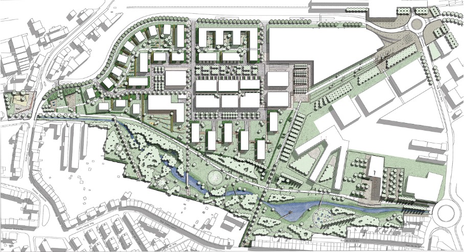
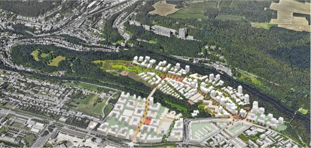
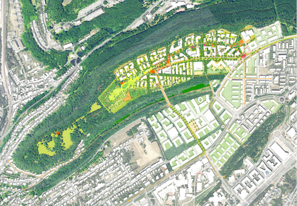
The Fonds Kirchberg launched a competitive consultation process to develop an urban design charter establishing objectives for the landscape of the Kuebebierg area, a major land reserve belonging to the public organisation. The 33-ha area is located in a so-called deferred development zone (zone d’aménagement différée, or ZAD). The winning team of the consultation process presented its project in March 2022. The consortium is led by the Güller Güller Architecture Urbanism office in Rotterdam and Zurich, cooperating with Zeyen+Baumann, Atelier Alfred Peter, Etienne Ballan, Cabane Partner, RR&A, ZEFCO, Ecolor, Ville en Œuvre and Belvédère.

Illustrated plan of the Kubebierg neighbourhood (Source: Güller Güller Architecture Urbanism)

Activities

With its circular design and ecological focus, Kuebebierg aims to create a vibrant, liveable community that integrates seamlessly with its surroundings. Activities within the neighbourhood are guided by a holistic vision that embraces the area’s natural and urban characteristics, prioritising principles of sustainability and community well-being.

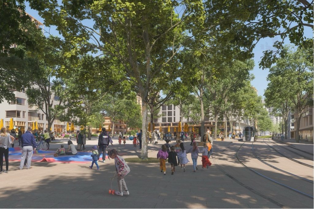
  1. Promoting Active Mobility: Kuebebierg prioritises diverse mobility options to reduce reliance on individual cars. Direct and secure routes for pedestrians and cyclists are integrated, along with the commissioning of a new tram line to enhance public transport accessibility.
  2. Limiting Car Circulation: With only one vehicle access point and a ratio of 0.5 cars per dwelling, Kuebebierg encourages a shift away from car-centric urban planning. Shared spaces accommodate various modes of transportation, fostering a safer and more vibrant urban environment.
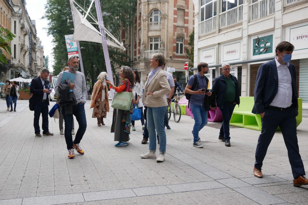
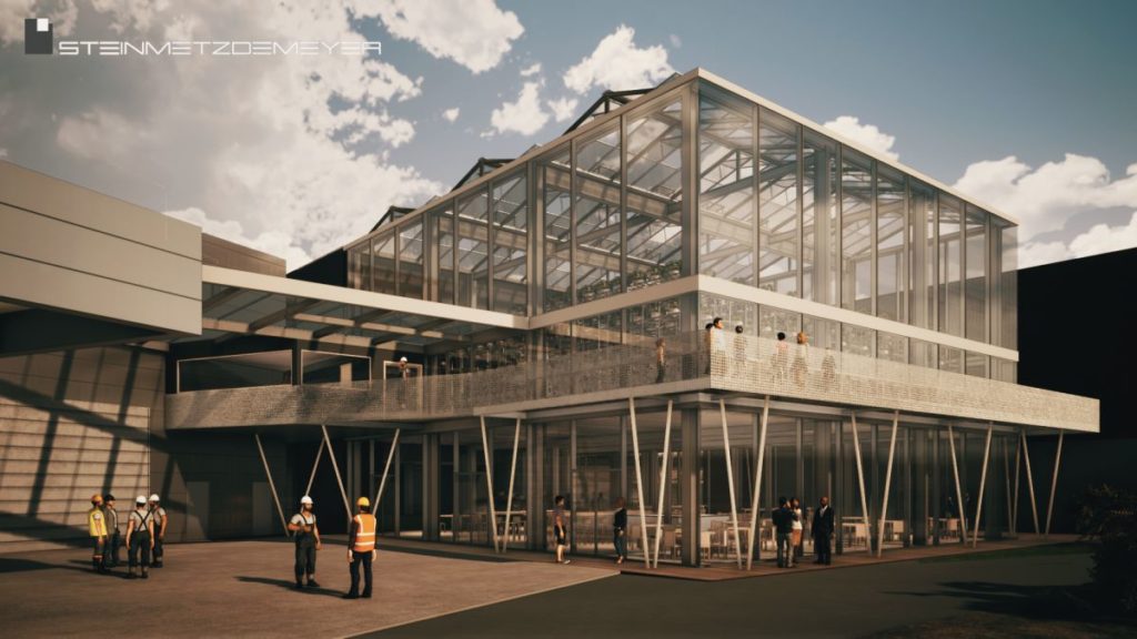
  3. Creating Vibrant Public Spaces: The heart of Kuebebierg features a bustling square, reminiscent of traditional city centres, offering a diverse mix of shops, restaurants, and recreational amenities. These vibrant public spaces serve as focal points for social interaction and community engagement. A linear park and the tram line will connect public spaces, crossed by the spaces “Porte Frieden” and the “Place du Kuebebierg”.
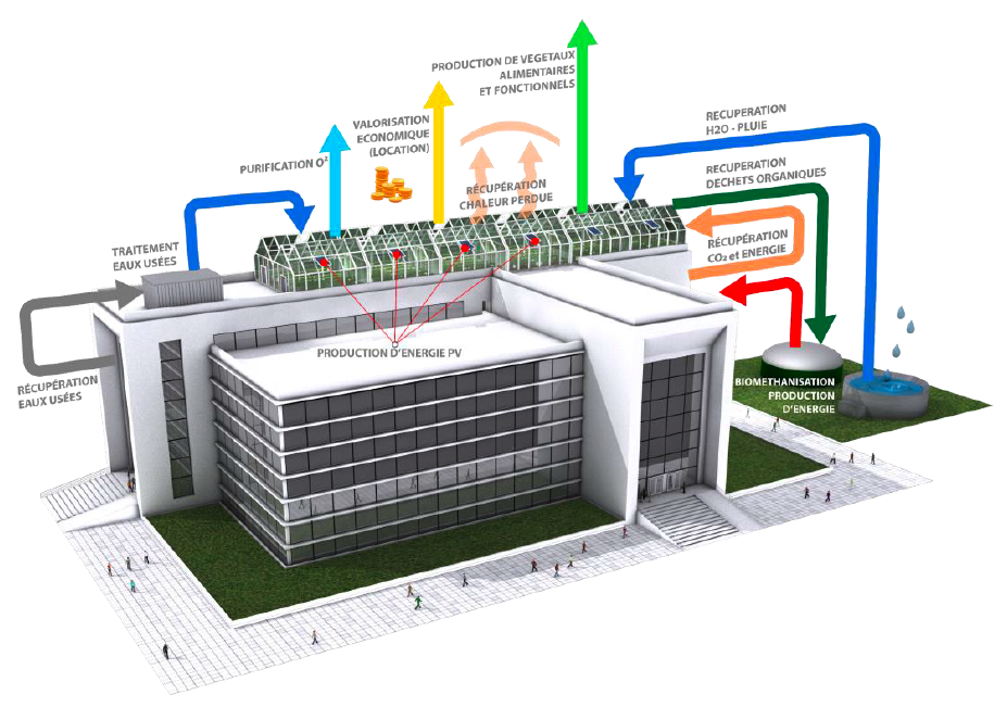
  4. Maximising Renewable Energy Production: Kuebebierg embraces energy efficiency by prioritising renewable energy sources. From efficient building design to on-site energy production and storage, the district aims to minimise its carbon footprint while ensuring optimal living conditions for residents.
  5. Fostering Social Diversity: With a balanced mix of housing typologies and amenities, Kuebebierg promotes social inclusivity and diversity. Affordable housing options, coupled with accessible public services and recreational facilities, create an environment where people from all walks of life can thrive.
  6. Living circularity: the planned programme for the site, the architecture and the infrastructures are all aiming for a high standard regarding carbon footprint, local consumption and low energy demands, etc. In this context, the concept includes for example an urban farm and gardening.
  7. Farming in the City: The city farm project aims to maintain agricultural activity on one of the last remaining sites on the Kirchberg Plateau worked by farmers. It promotes biodiversity through more extensive green space management and offers multifunctional farming activities, including grazing, market gardening, and agro-tourism, contributing to economic, environmental, and socio-cultural services within the community.
Place du Kuebebierg (Source: Güller Güller Architecture Urbanism)

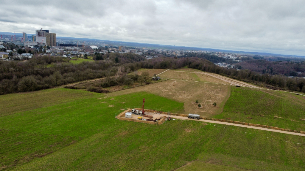
Status of Implementation

The implementation of the project started in 2022. At the western tip of the district, where the city farm and orchards are also planned, initial work began at the end of 2023 (planting trees and exploratory drilling for geothermal energy). This part of the district will also be included in the exhibition LUGA – Luxembourg Urban Garden taking place in 2025.

Onsite photo (Source: Fonds Kirchberg)

Outlook

The winning project for Kuebebierg embodies a vision of urban living in harmony with nature. By integrating topography and green spaces, creating pedestrian-friendly environments, and prioritising sustainability, Kuebebierg sets a new standard for future urban developments.

As construction progresses, Kuebebierg aims to become a living testament to the possibilities of sustainable urban planning. The aim is to achieve a district development plan for 2025, build infrastructure in 2027 and initiate the construction of housing in 2029. With its innovative approach and commitment to environmental and social well-being, Kuebebierg represents not just a neighbourhood but a vision of a more sustainable, inclusive, and resilient urban future.

Contact

Fonds Kirchberg: info@fondskirchberg.lu

References

Fonds Kirchberg (French): https://fondskirchberg.public.lu/fr/concepts-urbains/quartiers-futur/kuebebierg.html

Communication of the Luxembourgish government (French): https://gouvernement.lu/fr/actualites/toutes_actualites/communiques/2022/03-mars/02-urbanisation-terrains-kuebebierg.html

Paperjam article (French): https://paperjam.lu/article/kuebebierg-quartier-tourne-ver Record of the project presentation (French): https://www.youtube.com/watch?v=G56wT-yC8mw&t=38s

The Master Programme for Spatial Planning in Luxembourg, known as “Programme directeur d’aménagement du territoire” (PDAT) 2023, is the central element of the country’s spatial planning policy. Serving as a framework for a sustainable development of the national territory and for enhancing the quality of life of all citizens, the PDAT defines an integrated strategy for sectorial policies with a territorial impact and defines guidelines, objectives and measures for the government and municipalities. The newly adopted PDAT (21 June 2023), which was prepared by the Department of Spatial Planning in cooperation with an interministerial working group, builds upon a large public participation process in 2018 and the international consultation “Luxembourg in Transition” in 2020—2022.

Structure and objectives

PDAT 2035 (Source: Département de l’aménagement du territoire (DATer) 2023)

In order to frame the strategy, objectives and measures, the PDAT was developed in accordance with the following four guiding principles:

  • Increasing the resilience of the territory
  • Safeguarding territorial, social and economic cohesion
  • Ensuring a sustainable management of natural resources
  • Accelerating the transition of the territory to carbon neutrality

Based on those guiding principles, three policy objectives and a cross-cutting objective have been identified, addressing the development issues highlighted in the spatial analysis as well as the challenges imposed by climate, environmental, geopolitical and health crises:

1. Concentration of development in the most suitable places: Central to the PDAT’s mission is guiding sector policies and supporting municipalities in locating essential functions and services in the most suitable places. This aims to facilitate access to services, anticipate and reduce mobility needs as well as plan for critical infrastructure.

By guiding future development, the PDAT enables efficient infrastructure planning and a cost-effective implementation of sector policies. The territorial strategy encompasses an urban hierarchy based on Central Places (centres de développement et d’attraction, CDA), which is supposed to steer the spatial distribution of population (i.e. development) and employment growth (i.e. attraction) in a sustainable manner.

2. Reducing land take: The PDAT focuses on limiting the process of converting natural, agricultural or forest land into built-up areas. Decreasing land take offers several benefits, including mitigating the effects of climate change, preserving natural and semi-natural areas, minimising flood risks, protecting biodiversity, and fostering carbon sequestration. The goal is to gradually reduce land take from by 2035 and tend towards no net land take (zéro artificialisation nette du sol) by 2050.

Dynamics of soil artificialisation 2007-2018 (Source: Département de l’aménagement du territoire (DATer) 2023)

To achieve this, the PDAT puts forward a planning culture that promotes urban regeneration, multifunctionality and efficient land management.

3. Cross-border spatial planning: Taking into account the functional linkages between Luxembourg and its cross-border functional region, the PDAT recognises the need for a concerted territorial development in the Greater Region (Grande Région). To address ecological and climate transition challenges, the Master Programme promotes territorial development strategies for cross-border functional areas, consultation with neighbouring regions in the framework of planning processes, and cross-border resource management.

4. Collaborative Governance as a cross-cutting objective: In the PDAT, governance is considered to be a cross-cutting objective, emphasising the coordination required for effective spatial planning. This is meant to happen horizontally across sector policies, vertically between the State and municipalities, as well as through public participation.

Time Horizon

The PDAT2023 is meant to unfold in two phases: 2023-2035 and 2035-2050. The first period until 2035 will act as a transition phase, which contributes to reversing the current development trends. Actions will focus on identifying and adopting instruments for the implementation of the Master Programme as well as initiating pilot projects and stakeholder connections.

The second phase, from 2035 to 2050, will ensure a steady transition and reverse the trends in question by the implementation of the strategies, while monitoring the developments as well as adapting approaches as needed.

Programme directeur d'aménagement du territoire 2023 - Stratégies  territoriales - Portail de l'aménagement du territoire - Luxembourg
Vision 2050 in the PDAT (Source: Département de l’aménagement du territoire (DATer) 2023)

Implementation

In order to achieve the above-mentioned policy objectives in the given timeframes, two territorial strategies have been developed at different scales. First, the national territorial development strategy “Leitbild 2050” envisions a carbon-neutral and resilient territory, emphasising green, yellow and blue networks, the concentration of development in accordance with the urban hierarchy, and a sustainable mobility. This national territorial development strategy has also been broken down to so-called action areas (espaces d’action) at a functional-regional level. In this context, territorial visions for the three urban agglomerations have also been developed. Second, the territorial development strategy at the level of the Greater Region promotes cooperation in cross-border action areas, in accordance with the Interreg VI Greater Region programme. This cooperation fosters integrated territorial development in cross-border functional areas, complementing previous approaches by addressing challenges linked to the environment and natural resources. The implementation of strategies will be fostered through the adaptation of existing regulatory instruments and the potential creation of new ones.

Conclusion

The Master Programme for Spatial Planning in Luxembourg sets a forward-looking and ambitious territorial vision. By addressing climate change, resource preservation and sustainable growth, the PDAT paves the way for the ecological transition of the territory. Through clear strategic objectives and cross-sectoral coordination, Luxembourg is taking a further step towards sustainable development and enhancing citizens’ quality of life.

References

Master Programme for Spatial Planning in Luxembourg – “Programme directeur d’aménagement du territoire” (PDAT) 2023 (French): https://amenagement-territoire.public.lu/content/dam/amenagement_territoire/pdat-programme-directeur-damnagement-du-territoire-4072023.pdf

Spatial planning portal (French): https://amenagement-territoire.public.lu/fr/strategies-territoriales/programme-directeur.html

“Luxembourg in Transition” (LiT) can be characterised as an innovative process with the aim of rethinking and reshaping the territorial transition of Luxembourg and its neighbouring regions across the border by developing visions for a desirable future until 2050. The territorial visioning approach is innovative in the sense that it goes beyond traditional planning culture and instruments in an interdisciplinary manner and the spirit of coopetition.

Aim

The main objective of this innovative process is to develop different territorial visions, based on ecological transition scenarios, strategic spatial planning solutions and demonstration projects, for a decarbonised and resilient cross-border functional region of Luxembourg until 2050. The ecological transition refers to achieving the objectives of zero carbon emission while:

  • reducing land take;
  • enhancing biodiversity, improving ecosystem quality;
  • integrating the aspects of housing, transport, energy and digitalisation;
  • creating concepts and models for a territory resilient to climate change;
  • promoting an economic development that is stable, equitable and solidarity-based; and
  • strengthening territorial and social cohesion.

The territorial visions are based on the long-term horizon of 2050. By comparing the visions with the business-as-usual scenario, it becomes possible to identify the changes required for achieving the objectives and design a roadmap.

source: Luxembourg in Transition, 2020: Logo

Partnership

The LiT process was initiated by the Department of Spatial Planning of the Ministry of Energy and Spatial Planning. The consultation was accompanied by different committees: The Scientific Committee provided expertise from research and planning practice; the Advisory Committee incorporated the interests of partner and stakeholder organisations from Luxembourg and the Greater Region; the Interministerial Committee engaged all relevant sector ministries and steered the process; and the Citizens’ Committee (Biergerkommitee Lëtzebuerg 2050) introduced the population’s perspective and addressed recommendations to political decision-makers. An external service provider was tasked with the scientific management of the process and overseeing the work of the expert teams.

Activities

The international consultation within the framework of the LiT process was designed as a three-stage cooperative competition (“coopetition”), aiming to engage international experts from various disciplines and stimulate cross-fertilisation among teams. The consultation brought together practitioners, universities and other research organisations and gathered knowledge in the fields of regional and urban development as well as architecture, environmental and social sciences. The initial ten teams started working in October 2020 and the four final teams presented their results in January 2022. The three stages of the consultation aimed to refine and concretise the so-called “transition visions” developed in each preceding phase.

Stage 1: In this stage, the expert teams were tasked with developing a quantitative approach to assess the effectiveness of measures in reducing greenhouse gas emissions. The metrics needed to quantify various aspects related to land use, energy consumption, waste management, food production, water resources or biodiversity.

Stage 2: Building upon their work in Stage 1, the expert teams were required to apply their metrics to the territory and show how innovative concepts in spatial planning could be implemented. The focus was on the cross-border functional region of Luxembourg, exploring the potentials and challenges of implementing measures in a cross-border context.

Stage 3: The final stage called for the expert teams to develop concrete strategies and exemplary projects to anchor the vision both within Luxembourg and across borders. This stage emphasised topics such as energy efficiency, the protection of biodiversity, resilience and climate change adaptation, resource scarcity and food security.

University of Luxembourg et al., 2021: Representation of a converted commercial area

For instance, the team led by the University of Luxembourg presented measures for regenerating industrial parks and commercial areas through conversion, multifunctional usage, the use of local products and renaturing. The experts developed their vision using the example of the commercial area Foetz in Mondercange, Luxembourg.

Further projects and detailed information about the entire LiT process can be found on the website: https://luxembourgintransition.lu/en/

Outlook

The LiT process represents an innovative approach to shaping the future of Luxembourg. By engaging a diverse range of actors, implementing a multi-stage competition, and incorporating cross-border aspects, the process aims to develop a sustainable and resilient Luxembourg in a sustainable and resilient manner. The vision’s long-term horizon of 2050 provides a framework for setting goals, identifying necessary changes, and establishing a roadmap for this development. The next step is to shift from theory to practical implementation, which consists of pilot projects and demonstrating the ability of the functional region Luxembourg to transition towards a carbon-free territory. Additionally, the transferability and application of the LiT process in other territories – cross border or not – is illustrated in the Guidance Note “Cross-Border Spatial Planning: A vision for a cross-border functional region” which is a Pilot Action of the Territorial Agenda. It demonstrates the applied methodology and discusses the implications of decarbonisation and sustainability for spatial planning and its cross-border dimension. Find out more about the pilot action here: https://territorialagenda.eu/pilot-actions/cross-border-spatial-planning/

Contact

Luxembourg in Transition: https://luxembourgintransition.lu/en/contact-2/

References

The “National Platform for Urban Policy” (CIPU) enables cooperation between national, regional/intermunicipal and local level and initiates the debate around urban planning and development in Luxembourg. In addition to that, it raises awareness in the international context and informs about ongoing urban spatial planning trends and relevant topics in Luxembourg.

Aim

CIPU works on two levels: the European and the national level. While increasing awareness about spatial planning in Luxembourg in the international context, the platform simultaneously supports the cooperation between the local and the national level in Luxembourg. The central objective of CIPU has always been to provide a platform for exchange between the various urban policies and a multitude of municipal, national and European actors and enable cooperation – an objective which remains valid today. However, the practical topics have evolved across the years. The convention applies a focused and cooperative approach for its implementation.

Partnership

CIPU is based on an agreement between the Luxembourg Ministry of Energy and Spatial Planning, the Ministry of Housing and Ministry of Home Affairs as well as the cities of Luxembourg, Esch-sur-Alzette, Differdange and Dudelange. These partners constitute the core network of the CIPU. It is managed and organised by the CIPU which is run by Zeyen+Baumann in cooperation with Spatial Foresight. Depending on the subject, the platform’s activities are implemented in close cooperation with external partners, e.g. the Klima-Agence.

Patty Neu, November 2019: Presentation of CIPU publications during the press conference in November 2019, Claude Turmes, Minister of Energy and Spatial Planning and Henri Kox, Minister of Housing

Genesis

CIPU was developed in 2010 to support the integration of the recommendations for urban development from the European level in Luxembourgish spatial planning policy. In Luxembourg, the debate on spatial development since the beginning of the 2000s has been marked by the adoption of the second Master Programme for Spatial Planning (PDAT) in 2003, the Integrated Transport and Territorial Development Concept (IVL) in 2004 and the revision of the laws on urban (2004) and spatial planning (2013, 2018). CIPU initially aimed at transposing the objectives from the “Leipzig Charter on Sustainable European Cities” from 2007 at the national level while involving Luxembourgish municipalities in the implementation of a national urban policy, and – at the same time – considering the objectives of the PDAT which has a guiding function for national and local authorities.

Zeyen+Baumann, September 2021: CIPU excursion on Revitalising city centres in September 2021

During 2017-2021, a thematic focus was set for each year: In 2017/2018 the activities were focused on affordable housing. The year 2019 revolved around the topic of major urban development projects, the years 2020/2021 focused on both climate change adaptation in urban development and the revitalisation of inner cities. Furthermore, in the course of 2021, CIPU addressed the changing framework conditions caused by the COVID-19 pandemic and work was carried out under the overarching title “City in Transition”. In addition to workshops and events, which were dedicated to concrete issues and enabled a direct exchange between the participants, the results of the discussions were processed in numerous publications for Luxembourgish and European planners. These were produced in close cooperation with the partners involved in the CIPU and the actors participating in the workshops. The CIPU documentation is thus a significant output that actively contributes to informing and developing the expertise of Luxembourgish planners. In order to finalise this phase of CIPU and to provide space for other important topics in the future, the “Journée de la Politique Urbaine” was organised with Luxembourgish planners and experts in January 2022. In a world café-like setting, the future perspectives for a “City in Transition” were elaborated as a summarizing statement of the CIPU 2020/2021.

Patty Neu, October 2019: CIPU workshop on innovative urban development projects in October 2019

Outlook

The main topics and activities for the next two years are described in an ambitious programme. It was developed in close cooperation with all involved partners by means of in-depth discussions about relevant topics. This action programme will cover the following topics:

  • multifunctional urban areas
  • energy concepts for large-scale urban projects
  • climate resilience and climate change impact in urban development
  • building cooperatives and alternative models for housing and working

Activities for 2023 were launched in May with the online lecture series (colloque) consisting of four presentations on energy concepts in the district “Roud Lëns”, the projects “NeiSchmelz” and “Wunne mat der Wooltz” as well as the energetic renovation of existing buildings in Differdange and a low-emission district in Strasbourg. Further steps in the implementation include interactive thematic workshops, an excursion and a concluding conference on the second thematic focus of multifunctional urban areas. For external communication, and awareness-raising, CIPU will inform about ongoing activities, publications and provide a collection of funding opportunities for municipalities on its website and social media. Furthermore, this blog will inform continuously about ongoing urban planning and development trends and projects in Luxembourg – so stay tuned during the next months.

Contact

Cellule nationale d’Information pour la Politique Urbaine (CIPU): cipu@zeyenbaumann.lu

References

CIPU website (German and French): https://site.cipu.lu/

CIPU blog (English): https://blog.cipu.lu/blog/

Conclusions of CIPU 2020/2021 (German): https://site.cipu.lu/images/2022-03_publications2022/CIPU_Conclusions%202020-2021_2022-03-30.pdf

Frequent extreme weather events in Luxembourg in recent years have pushed climate change higher up the public agenda. The call for more public action has become louder in view of the devastating effects of recent tornados and torrential rainfall, followed by flooding and extended drought in the summer noticed by residents and visitors.

Preparing and adjusting to current and future effects of climate change, ‘climate change adaptation’, is one pillar next to climate action that governments around the globe are working on to limit the impact of climate change on societies.

Despite progress made during past years, there are critical gaps in implementation of climate action, where policy ambitions have not yet yielded necessary action. This highlights the need for clear information and guidance to streamline actions to progress towards a shared agenda for practitioners and planners. The ‘Climate Change adaptation strategy’ comprehensively promotes climate change adaptation in Luxembourg.

Rationale for action

According to IPCC scenarios, by the end of the 21st century, Luxembourg will experience today’s climate of Milan. What sounds positive at first glance has serious consequences with average annual temperature rising from 8.8 to 13.1° Celsius and rainfall increasing by 30% over the next 80 years.

These numbers should not distract attention from expectations of more frequent extreme weather events including heat stress, rainfall variability, less available freshwater, lower crop yields, lower soil quality, uncertain energy supply, increasing conflicts of use and less biodiversity. These show the current system is not yet ready to cope with climate change.

Despite these observations, climate change adaptation still appears to be a side note in Luxembourg spatial planning. With municipalities responsible for planning, state institutions depend on municipal decision makers and planners being informed and willing to work towards climate change adaptation. To become more resilient to a changing climate, more attention needs to be given to climate-change adaptation to prepare for inevitable impacts as the current system is not yet prepared.

Objective

Preventing harm to humans and natural ecosystems from climate change requires adapting the built environment. The fundamental assumptions on which local planning and developments have been based for decades have changed, especially for water availability and amount of rainfall.

Much more than simple adaptations are necessary. With changing fundamental assumptions on climate, new techniques and methods are needed. This means new methods to cope with the new reality and to adapt existing systems.

Transition is very complex. It requires modifications to the way we have planned for decades. So planning guidance is essential, along with a national reference framework to detail and measure the effectiveness of actions to induce significant change. The Climate Change Adaptation Strategy provides this guidance. It gives information from Luxembourg planners for Luxembourg planners about climate change adaptation.

Time frame

The strategy has been updated frequently since the first edition in 2012. New planning laws and regulations made an update necessary in 2016 and a new edition was published in 2018 which remains valid today. To assist local decision makers and planners, the new edition also has an implementation strategy.

Key players

The strategy has been developed by the Department for Environment of the Luxembourg Ministry of Energy and Spatial Planning, which is also responsible for implementation. It works towards the Paris Agreement and has been adopted by the Government so it applies to all government institutions.

Cover page of the C-Change strategy. Source: MEV, 2021.

Implementation steps and processes

The climate change adaptation strategy offers a comprehensive catalogue of measures. It covers construction and housing, energy, forestry, infrastructure, civil protection, spatial planning, agriculture, human health, ecosystems and biodiversity, tourism, urban development, water management and the economy. There are also specific recommendations on cross-cutting measures.

There are several measures for each topic and every measure is described in a factsheet. These detail the objective, the type of measure, necessary steps, additional information, stakeholders and success indicators.

With the detailed factsheets, the strategy also offers guidance and information on responsibilities. Municipalities can identify measures based on the desired effects of their actions.

Required resources

The resources used to create the strategy are not known.

Results

The strategy has been developed in a participative process, involving municipal and national planners. Recommendations respect the national and local planning regulations.

Every recommendation is explained in a table format (see below). It comes with a detailed description, ensuring that a measure follows the climate change adaptation strategy. Key stakeholders to implement recommendations are also detailed.

Despite the comprehensive guidance, measures still need to be translated into the local context by municipalities. This ensures that decisions respect local specificities. It also ensures municipal planning autonomy, a valuable commodity in the Grand Duchy.

The strategy has been adopted by the Luxembourg Government. All public institutions are asked to consider the document in the planning of public projects.

Example of a recommendation in table format from the strategy. Source: MEV, 2021.

Experiences, success factors, risks

Adapting spatial planning to climate change is a difficult task. The strategy contains much useful information for planners and experts, helping to inspire national and local action.

Conclusions

The strategy is a reference document for climate change adaptation from 2018 to 2023. After 2023 it will be revised and updated again, to incorporate new knowledge and new planning legislation.

Contact

Contact: https://environnement.public.lu/fr/support/contact.html

References

Ministry of the Environment, Climate and Sustainable Development, Strategy and action plan for climate change adaptation:

German: https://environnement.public.lu/content/dam/environnement/documents/klima_an_energie/Anpassungsstrategie-Klimawandel-Clean.pdf

French: https://environnement.public.lu/content/dam/environnement/documents/klima_an_energie/Strategie-Adaptation-Changement-climatique-Clean.pdf