The Grand Duchy of Luxembourg, at the heart of Europe, continues to gain about 2% in population every year. The South of the country, the former industrial area, is growing especially rapidly, by a quarter since 2010 and in 2021 it hosted a third of all residents. Demand for housing has increased and is one of the most rapidly increasing expenses for Luxembourg households today.

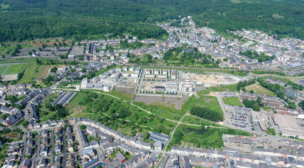
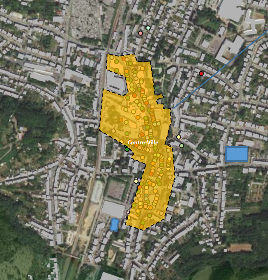
In the already urbanised South, many large-scale development projects for new districts on industrial brownfields are being realised or are in the pipeline. This impacts the urban morphology of the area. Formerly geographically separated urban districts are now connected. But how can new districts interconnect urban fabrics, let alone urban functions? Differdange, the third largest city in Luxembourg, is home to such a brownfield project, ‘Plateau du Funiculaire’.

Rationale for action

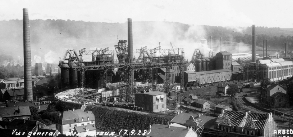
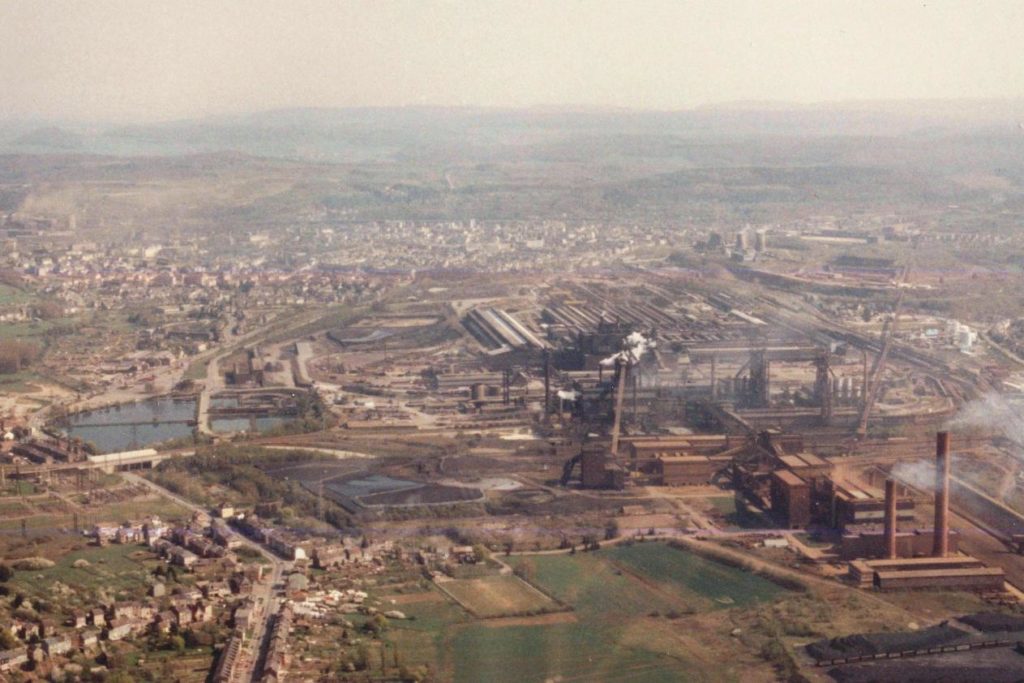
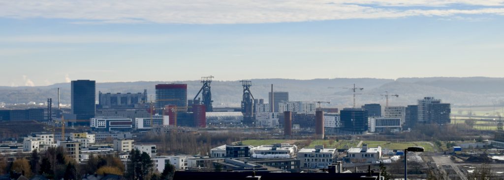
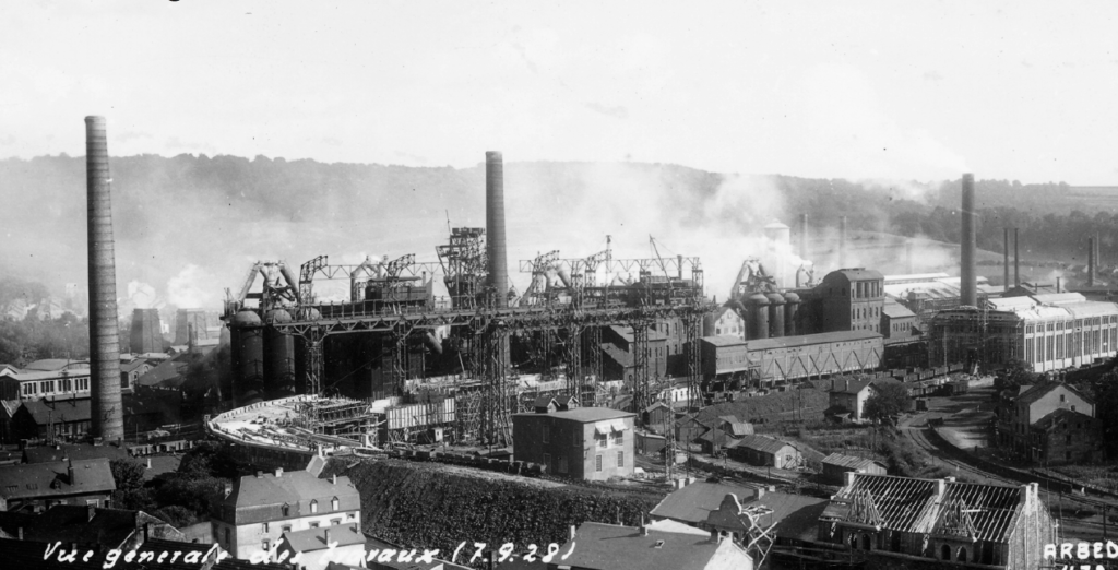
The rapid development of the steel industry in Luxembourg during the 19th and 20th centuries created a unique urban tissue in the South. Housing was built around steel mills, as in other industrial areas. This resulted in large industrial zones being next to urban centres. In some cases, as in Differdange, these industrial zones are ‘wedges’, impermeable barriers that separate districts functionally.

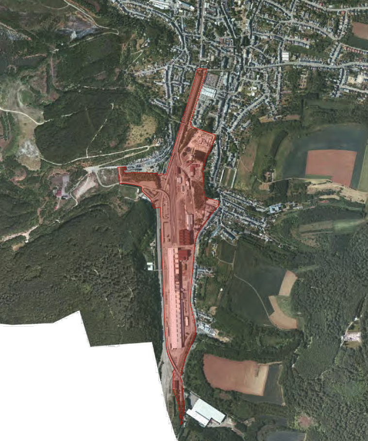
Steel production in Luxembourg has declined over several crises and steel mills have reduced or entirely stopped production. Around 2000, some 25 hectares became available in the centre of Differdange. The ‘Plateau du Funiculaire’ was formerly a landfill for the adjacent steel mill.

Urban development concept of the ‘Plateau du Funiculaire’. The urban district of the development is shown in the upper part of the image with the new shopping centre ‘Opkorn’ in the upper right corner. The park along the Chiers is shown in the bottom half of the image. Source: Dewey+Muller, 2022.

Objective

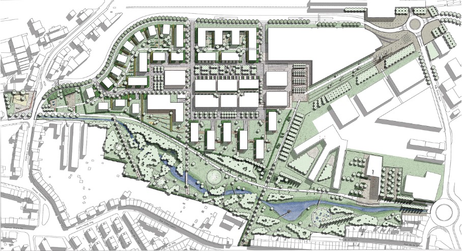
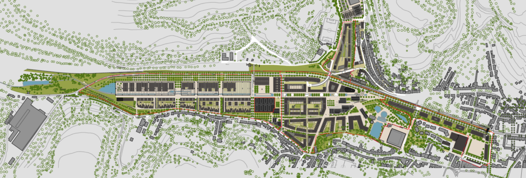
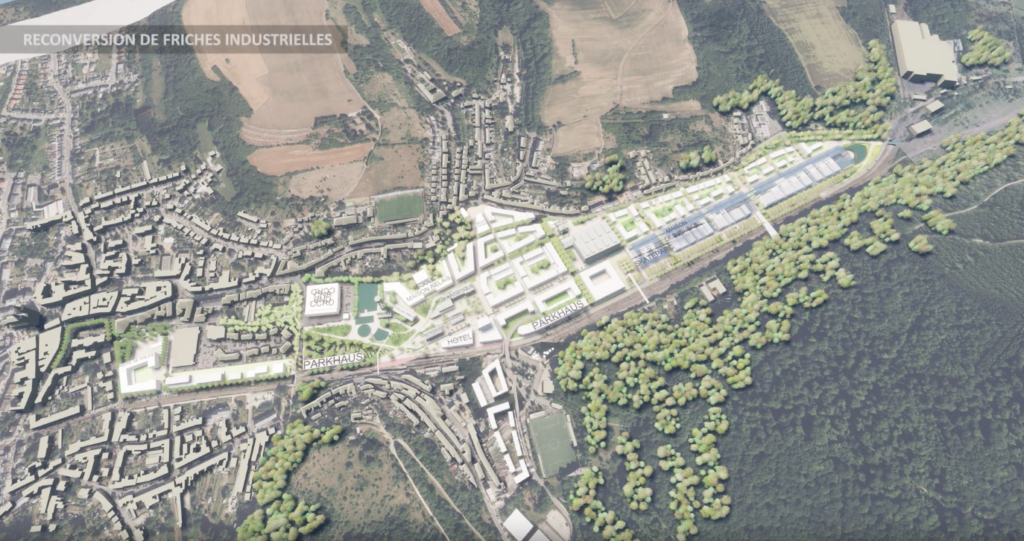
The Plateau du Funiculaire functionally split several Differdange districts, so plans were drawn up to transform the brownfield site into a new urban district. From 2004, the city has developed urban concepts in cooperation with many local and national players. A new district, providing housing, offices and commercial areas is planned to connect the existing districts of Differdange, Oberkorn and Fousbann.

Some challenges had to be addressed in developing the urban concepts, including pollution of the area due to its use as landfill for the blast furnace. In addition, the river Chiers running through the area was planned to be renaturalised, to provide water retention and flood areas.

Time frame

The first scoping studies were realised as early as 2004. Since then, planning and construction has been ongoing with most of the district being finalised in 2020. Final construction during 2022 will complete the project on the former landfill.

Key players

The key player for developing the new area was the city of Differdange. The urban concept was developed with a Luxembourg planning office as well as an investor.

Looks and feels of the urban design of ‘Plateau du Funiculaire’. Source: LuxEnergy S.A., 2021.

Implementation steps and processes

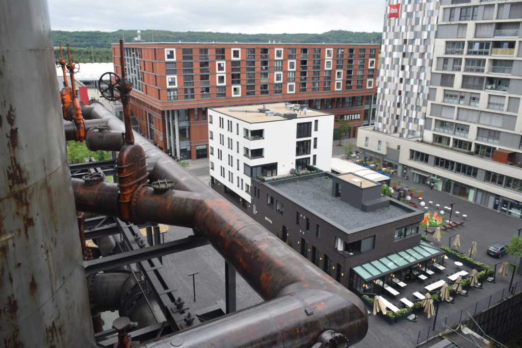
Following the first plans to develop the district in 2000, initial research in 2004 assessed the landfill pollution. At the same time, the city of Differdange also outlined strategic objectives for the district. In 2005, a planning office proposed the look and feel of the new district as an urban concept. Development started in 2006 when the historic ‘Villa Hadir’, a former reception and administrative building for the blast furnace was refurbished. Plans to implement the urban concept were submitted for building permits.

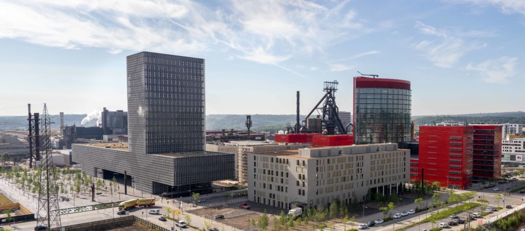
A brand was created in 2007 to establish an urban identity to market the new district to future inhabitants, businesses and commerce. Work on the infrastructure started in 2009 and the first bricks for the residential buildings were laid in 2011. In the same year, the recreational park was finalised, allowing neighbourhood residents to get to know the new urban district. Around 2019, a late change to the project integrated a multi-functional tower, called ‘Gravity’, increasing the number of planned housing units from 650 to 728.

Required resources

The resources used are not known.

Results

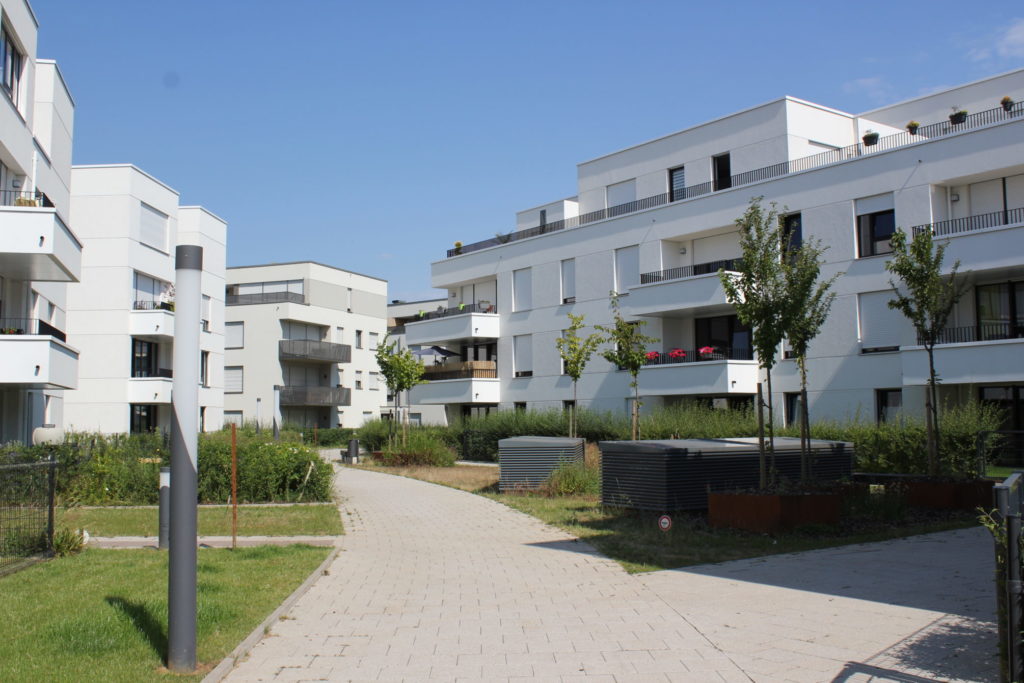
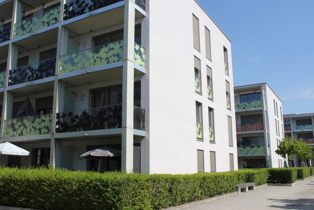
After a bit more than a decade of construction, the new district will be finalised in 2022. Within 10 years, 728 housing units have been created, providing accommodation for more than 1,600 people. The district also features 15 km2 of office and retail area. A school, a section of Luxembourg university, public administrative offices and shops complement the housing so the district is a fully developed urban quarter of Differdange.

A new train station links the area to the national railway network. In addition bus connections as well as bike and pedestrian infrastructure connect the district both internally and to the surrounding areas.

To minimise soil sealing, ‘Plateau du Funiculaire’ is high density. Nevertheless, some polluted parts of the former landfill were sealed with an artificial layer of clay so surface rainwater can drain into the nearby river. Rainwater that penetrates polluted soil layers is collected separately for treatment.

Residential blocks in the ‘Plateau du Funiculaire’ district. Source: LuxEnergy S.A., 2021.

Experiences, success factors, risks

The relatively short construction period of ‘Plateau du Funiculaire’ highlights good preparation. Potential obstacles were identified, and solutions developed to avoid these.

The urban concepts and building permits provided planning security. The late modification to include a multi-functional tower in the district shows the project adapted to changing demands. Such flexibility is important as needs and requirements usually change for decade-long large-scale urban development projects.

Conclusions

‘Plateau du Funiculaire’ is a prime example of a successful large-scale brownfield development project. Such projects can close functional gaps between urban districts, offering new housing and commerce. In addition, interests from multiple public and private stakeholders can be addressed in one go. It also shows innovative approaches to issues like polluted soils that are frequently encountered in brownfield developments.

‘Plateau du Funiculaire’ also underlines that brownfield development offers much more freedom compared to developments in existing urban areas. Measures can be discussed before being realised in detail, helping to avoid conflicts.

In addition, brownfield development projects such as ‘Plateau du Funiculaire’ are testbeds for new approaches and technologies. The size of the district meant that planners faced challenges that could not be solved with existing planning approaches. An example is heating for the residential units where a centralised district heating system was planned as early as 2007 to reduce infrastructure costs and save energy.

Today the district offers a new face for Differdange and combines different urban functions in an optimal way. With multiple housing and commercial possibilities, ‘Plateau du Funiculaire’ will eventually become the new centre for the town.

Contacts

Urban technical service of Differdange: pag@differdange.lu

References

Dewey Muller, 2018: Plateau du Funiculaire project presentation (German): https://www.deweymuller.com/projekte/plateau-du-funiculaire/

Aurea Differdange, 2020: Project developer website (in French): https://www.aurea-differdange.lu/fr/localisation

Celebrating the accession of the city of Differdange to the CIPU convention, we interviewed Laura Pregno, alderwoman for urban development and Manuel Lopes Costa, chief planner for the City of Differdange. Differdange is the third-largest city in the Grand Duchy of Luxembourg. The interview covered climate change adaptation and climate action in Luxembourg urban areas.

Interviewer: Measures addressing climate change can reduce hazardous emissions, or deal with the consequences of climate change. What role does local development play in adapting to climate change?

Alderwoman Pregno and chief planner Lopes Costa: Urban development is important to climate change adaptation with municipal measures aligned to broader objectives. The city of Differdange directly contributes to Sustainable Development Goal 11 ‘Make cities and human settlements inclusive, safe, resilient and sustainable’ through a municipal guideline.

Sustainable Development Goal 11. Source: UN, 2021.

The 2018 guideline lays out principles and objectives for renovation and construction of public buildings in Differdange (available here in German). It directly refers to the Sustainable Development Goals, linking municipality measures to global climate change adaptation and climate action. When implementing local measures, it is important to consider these overarching objectives and strategies as this ensures that players at all levels are working towards the same objectives creating synergies and avoiding conflicts.

Linking municipal efforts to broader global policies still leaves municipalities free to adapt their own visions, strategies and objectives. We develop our own visions and strategies for climate change adaptation and climate action through urban and district development in our city. Referring to the global objectives helps us to use monitoring, with measurable effects that are visible for Differdange residents.

Differdange uses municipal planning to involve citizens, associations, public institutions and services as well as businesses. In addition, our starting point for climate change adaptation differs from other places. In Differdange we have different pre-requisites than elsewhere, calling for territorially integrated actions and measures. Urban and district development instruments help us to incorporate local specificities in policy making.

Interviewer: Where do you see priorities and opportunities to use existing or new spatial planning and urban development instruments for climate change adaptation in Luxembourg?

Alderwoman Pregno and chief planner Lopes Costa: Luxemburg municipalities already have a range of instruments to hand that enable climate change adaptation and climate action to be integral in urban development. From our point of view, these instruments are sufficient for such measures.

However, climate change adaptation and climate action often lack clearly defined objectives and measures at municipal level in Luxembourg. In Differdange and other municipalities instruments could not be used to their full potential to carry out projects as there were unclear overarching objectives. These ambiguities have their origin in political disputes or a lack of climate-related strategies at municipal level.

This is why we, the city of Differdange, are working on clear politically approved objectives. An urban strategy is currently under development which will align all urban development projects in Differdange to contribute to climate change adaptation and climate action. The strategy will complement the existing guideline and is being developed jointly with citizens and across political parties, ensuring that all parties will work on its implementation.

Once these clear and politically approved objectives are defined at local level, we can use urban development and planning to their full potential to implement concrete measures. Our strategy will ensure that climate change adaptation and climate action objectives are addressed in urban development. The local zoning plan, PAG (Plan d’aménagement general) will influence land-use in favour of climate change adaptation, with specific land-use plans (Plan d’aménagement particulier)and urbanistic concepts for vacant land (Schémas Directeurs) enabling measures for private or public development projects, such as building layout and even construction materials.  

Interviewer: What role should climate change adaptation play in a sustainable urban development?

Alderwoman Pregno and chief planner Lopes Costa: In Luxembourg, impacts of climate change have become more visible in recent years. More frequent torrential rains, droughts and hazardous events have put climate change back into the population’s awareness. The most important instrument we as the city of Differdange have to counter these changes is sustainable urban development. Changing our urban landscape and making it more fit for the future will guarantee that our city remains liveable. Nevertheless, to make sure that we are all moving into the same direction we need joint visions and strategies. With our climate strategy, we increase leverage of our measures as we commit all political parties to shared objectives and measures.

Master plan for the ‘Plateau du Funiculaire’ in Differdange. Source: Dewey Muller, 2020.

Interviewer: Can converting urban brownfields help climate change adaption?

Alderwoman Pregno and chief planner Lopes Costa: We have brownfield conversion experience with the large development project ‘Plateau fu Funiculaire’ in the centre of Differdange. Since 2004, we have been developing this district together with many stakeholders. The brownfield was a former dumpsite for the nearby blast furnace and was developed in a way that connects the city districts of Differdange, Differdange, Oberkorn and Fousbann. We also re-naturalised the river Chiers with special attention on providing natural flooding surfaces.

This large-scale brownfield development has much more freedom compared to developments in existing urban areas. We discussed and balanced measures before they were realised in detail. This has helped to avoid conflicts. Also, planners optimally balance the three pillars of sustainable development; economy, ecology and society at project level.

However, this process takes time. It is important that concerns on climate change adaptation and climate action are considered in the planning process from the very beginning. Only then can the different needs and requirements be balanced through iterative discussions and negotiations between sector experts, so operational concepts can be developed and implemented.

In addition, brownfield development projects such as ‘Plateau du Funiculaire’ serve as testbeds for new approaches and technologies. Its size meant we faced challenges that could not be solved with existing planning approaches. An example is providing heat to the 600 units in the district. The area was planned with a centralised district heat system as early as 2007 to reduce infrastructure costs and to save energy. The idea could only be adopted later, but time is available in such large-scale brownfield developments.

‘Plateau du Funiculaire’ from above during construction. Source: Dewey Muller, 2020.

Interviewer: Thank you and we will definitely cover the ‘Plateau du Funiculaire’ project in our upcoming descriptions of good practices from Luxembourg. What is the role of the CIPU for climate change adaptation in Luxembourg?

Alderwoman Pregno and chief planner Lopes Costa: The National Information Unit for Urban Policy (CIPU) is a platform to liaise partners and other players in Luxembourg on climate change adaptation. In addition to our measures in Differdange, all cities and municipalities across Luxembourg develop and implement climate change adaptation and climate action measures. CIPU events, workshops and related activities help bring this knowledge and experience together to create new knowledge. CIPU also facilitates discussion on difficulties encountered when implementing measures to support climate change adaptation and climate action. Critical reflection in the framework of CIPU events is crucial to designing and implementing changes to improve urban development in the country.

For any questions on the article, please refer to the author: sebastian.hans@spatialforesight.eu

Many brownfield development projects are under way in the Grand Duchy of Luxembourg. ‘Porte de Hollerich’ in Luxembourg City, ‘Belval’ in Esch-sur-Alzette, ‘Wunne mat der Wooltz’ in Wiltz and ‘NeiSchmelz’ in Dudelange are a few examples. All these are creating new urban districts with living space for many additional inhabitants and businesses. The ‘NeiSchmelz’ project in Dudelange will provide an additional 1,000 housing units on a 40 hectare brownfield site.

Large-scale brownfield development projects present many challenges for their cities, especially energy. In addition, existing infrastructure struggles to satisfy the increased demand. For ‘NeiSchmelz’, an innovative energy concept was developed, to use photovoltaics and deep geothermal energy.

View on the steel mill in 1928, that occupied the area of ‘NeiSchmelz’. Source: City of Dudelange, 2017.

Rationale for action

Because of its size, the ‘NeiSchmelz’ brownfield development poses significant challenges for the existing energy network. This would need to be extended if not complemented with new production facilities. As infrastructure investment significantly increases the cost of such projects, an alternative solution was needed.

‘NeiSchmelz’ was therefore planned as an eco-district. Renewable and carbon-neutral energy will be produced on site, i.e. not relying on fossil resources to supply electricity or heat. There are no centralised renewable energy production facilities in the area, so future energy in the district must be produced on site.

Planners had to develop an energy concept that relies on different energy sources. These will be photovoltaic installations (roofs and open ground) as well as the first deep geothermal drilling in Luxembourg. However, being the first in Luxembourg to drill 2,000 meter down, experience is scarce and the viability and potential had to be determined first.

Objective

Deep geothermal drillings are costly and innovative measures require intensive scoping-studies and test drilling to investigate whether this energy source is financially viable.

The potential for geothermal energy around ‘NeiSchmelz’ is significant. This has led to further investigation to assess drilling for heating in the district.

A first study on geothermal potential in Luxembourg was a doctoral thesis at the German Research Centre for Geosciences and the Luxembourg Geological Service between 2010 and 2015. A more concrete feasibility study included several drillings to test technical details and feasibility.  

Video of the ‘NeiSchmelz’ project from the National Fund for Housing ‘Fonds du Logement’, 2021.

Time frame

The first energy concept for the district was developed in 2014. In 2015 important geothermal energy potential in ‘NeiSchmelz’ was identified. A new energy concept was developed in 2017 building on geothermal energy as a primary source for heat. A feasibility study between 2017 and 2019 determined the potential in greater detail.

Key players

The driving force behind the district and the energy concept is the City of Dudelange. It approves the energy concept and the land-use plan as well as following up on implementation of the measures. The district is being developed in cooperation with the Luxembourg Ministry of Housing and the national fund for affordable housing ‘Fonds du Logement’. The Luxembourg Ministry of Environment and its energy department is also a key player for developing and realising the districts’ energy concept. The City of Dudelange can thus rely on the support of national institutions in developing and implementing the plans.

Implementation steps and processes

With little experience of deep geothermal drillings among the involved institutions, preliminary investigations were required. A feasibility study measured the geothermal energy potential including test drillings of 300 to 400 meters between 2017 and 2019 in the area of the future district. The feasibility study determined that deep geothermal energy could supply the entire district with heat. At 2,000 meters temperatures of 70° to 80° Celsius yield enough heat to supply the district with hot water.

Required resources

The preparatory analysis including the feasibility study and test drillings cost about half a million Euros. This was co-funded by 40 % from the Luxembourg European Regional Development Fund (ERDF) programme. The total resources planned for deep geothermal drilling is unknown.

Results

‘NeiSchmelz’ will be equipped with a district heat system powered by a centralised geothermal energy plant. In conjunction with photovoltaic installations and near-surface geothermal energy, ‘NeiSchmelz’ will be an energy self-sufficient development.

Experiences, success factors, risks

Geothermal energy is new to Luxembourg and knowledge of potential, techniques, feasibility and economic viability are still scarce. In developing the concept and the feasibility study, cooperation between specialised players is key to ensuring that knowledge is institutionalised. This will help when implementing similar projects in future.

Urban development concept for the ‘NeiSchmelz’ district. Source: City of Dudelange, 2017.

Conclusions

Geothermal energy means the heat for all ‘NeiSchmelz’ will be from a renewable energy source. In conjunction with extensive photovoltaic installations, the district will have energy self-sufficiency and be a zero-carbon emissions district. As such, it is the first in Luxembourg, offering important experience for future large-scale brownfield developments in the country.

Contact

Mr Patrick Hoss, Director of the ecological department of the City of Dudelange: patrick.hoss@dudelange.lu

References

Tageblatt, 2018: Newspaper article on the planned use of geothermal energy in Dudelange (in German): https://www.tageblatt.lu/headlines/das-heisse-potenzial-von-duedelingen/

City of Dudelange, 2019: Chronology of the development of the brownfield development ‘NeiSchmelz’ (in French): https://www.dudelange.lu/fr/projets-urbains/projet-neischmelz

Urban retailers face increasing competition through changing consumer behaviour including online shopping and greenfield shopping centres. This leads to vacant retail areas within cities, as customer footfall is channelled away from the centres.

This trend affects the commercial landscape in Luxembourg. Nevertheless, there is almost no data being collected that could help to provide a deeper understanding of the trend and how it can be counteracted. So, the General Directorate for Small and Medium-Sized Enterprises of the Luxembourgish Ministry of Economy, the Chamber of Commerce and the Luxembourg Confederation for Commerce (CLC) initiated the ‘Pakt PRO Commerce’.

The pact will help leverage the economic situation of retailers. A key part of the instrument is the Commercial Observation Register, a new tool to document and categorise businesses across the country. It can be used to analyse the commercial landscape and to inform decision-makers on where there is a large range of retailers and hence centrality as well as potential locations for additional retailers.

Rationale for action

The retailing sector is just one of the many sectors affected by digitalisation as more and more sales volume is generated online. In Luxembourg, between 80% and 90% of the population regularly shops online while only 10% of Luxembourg based shops offer products via the internet. In addition, many greenfield developments for large retailing centres are currently underway, probably decreasing customer footfall in city centres.

These trends threaten the survival of small urban retailers, as their customer base declines. Therefore, more and more retailing space risks being left vacant, which decreases the retail supply and the attractivity of city centers.

Objective

Increasing the understanding of ‘Why?’ and ‘How?’ these processes happen is the main objective of the Commercial Observation Register. This is a nation-wide database of retailers and their characteristics, enabling analysis of the commercial landscape in a city or municipality.

With the aid of data, the Commercial Observation Register can help answer critical questions for developing the urban commercial landscape, such as; ‘What trends shape and form a city’s commercial landscape?’, ‘How does the commercial landscape of a city look?’, ‘Where are the best locations for retailers currently?’ and ‘Where are ideal locations for new retailers?’. The answers assist decision making on urban development.

Time frame

‘Pakt PRO Commerce’, which includes the Commercial Observation Register, was launched in 2016. Collecting information on urban retailers in Luxembourg was completed in February 2019.

Key players

‘Pakt PRO Commerce’ was launched by three partners; the General Directorate for Small and Medium-Sized Enterprises of the Ministry of Economy, the Chamber of Commerce and the Luxembourg Confederation of Commerce (CLC). During the test phase, the Commercial Observation Register has been implemented and managed by the latter organisation.

Users of the Commercial Observation Register are municipal or national policy makers looking to make decisions that could impact the retail landscape.

Based on information from the Commercial Observation Register, the location and typology of shops could be mapped to identify the inner city area of the City of Dudelange. Source: CLC, 2018.

Implementation steps and processes

The Commercial Observation Register is a national database regrouping information on the locations and types of retailers. The CLC, in charge of implementation during the pilot phase, started designing the analysis tool in 2016. Since then, information about each retailer in the country has been surveyed, including address, name, type, size of retail space, business model and type of distribution. These results are fed into a central Geographic Information System (GIS) and can be used for further processing and analysis.

For first-hand analysis, the GIS database can provide information on all retailers in a given location at any time. For more in-depth analysis, the GIS database can be complemented with market analysis, i.e. purchasing power, location analysis and turnover forecasts.

Required resources

The first pilot phase of the Commercial Observation Register has been finalised in 2018. It is planned to make the tool accessible to decision-makers during 2021. However, information on required resources are not available. How the different municipalities and policy makers will be able to benefit from the Commercial Observation Register will be determined after first projects will be finalised, using information from the Register.

Results

With the Commercial Observation Register, municipalities and policy makers can access a versatile tool supporting decision-making. It enables appropriate strategic decisions shaping future commercial landscapes in cities and municipalities. The tool enables definitions of commercial centres, decisions on locating new retailers and understanding impacts of trends, such as digitalisation, on the urban retailing environment.

To elaborate additional benefits and applications of the Commercial Observation Register, the instrument will be tested in five cities. This will enable additional conclusions on specialised applications as well as the data and analysis required to react to specific issues, such as shop vacancy, parking and accessibility, trends in the retailing sector and more. Testing the tool will also provide insights as to when the information can be used best to shape local decision making. This helps to create tailor-made and result-oriented applications for the various retail sector players in Luxembourg.

Potential use of the Commercial Observation Register can be illustrated through development of the new district ‘am Duerf’ by the municipality of Dudelange within the city centre. This new district helped to bridge a commercially deserted area between the two main commercial centres. The number of businesses has increased from 167 to 215 (2018) in just three years, increasing the attraction of the city centre. Also, two commercial hotspots which were formerly separated could be transformed by the ‘am Duerf’ development into a single, continuous retail district (see Map).

The pilot of the Commercial Observation Register has been extended in 2019 on the cities of Esch-sur-Alzette, Diekirch, Remich and Bertrange, addressing different challenges to urban retailers throughout the country.

Map of the commercial situation before and after development of the ‘am Duerf’ district. Source: CLC, 2018.

Experiences, success factors, risks

In the future, the Commercial Observation Register will become a powerful tool to assist policy makers in shaping development of the retailing sector. Not only location, but also decisions on retail space needs can be influenced by the tool. However, the Commercial Observation Register relies on an extensive data collection procedure. Only if data is collected regularly in every municipality can there be reliable observations on trends. This might reflect on the operational costs of the tool for its stakeholders.

Conclusions

The Commercial Observation Register is an instrument with a lot of potential applications to shape retailing functions in Luxembourg’s cities and municipalities. It informs policy makers about the retailing landscape, type and development of supply so they can make decisions considering changing consumer behaviour. Even though such an instrument is not new to the set of tools available to urban planners, it is the first of its kind in Luxembourg. More initiatives like the Commercial Observation Register supporting domestic retailers and shop owners, such as the online platform “Letzshop”, have been implemented recently.

Contact

General contact address of the Luxembourg Confederation of Commerce: info@clc.lu

References

Pact PRO Commerce, 2018 (in French and German): https://www.procity.lu/fr/2018/07/16/quelle-valeur-ajoutee-le-nouveau-cadastre-du-commerce-offre-t-il/

Luxembourg Confederation for Commerce, 2018: The new Commercial observation register for Luxembourg. What’s the added-value? (in German): https://www.procity.lu/2018/07/16/das-neue-cadastre-du-commerce-welchen-mehrwert-bietet-es/

Wort, 2020: Le cadastre commercial fait attendre (in French): https://www.wort.lu/fr/luxembourg/le-cadastre-commercial-se-fait-attendre-5e4417feda2cc1784e3560fe

The south of the country of Luxembourg has a strong industrial heritage. During the 19th and early 20th centuries, the area was home to a large steel manufacturing sector. Due to direct access to iron ore, the steel industry predominantly settled nearby. Steel mills were built next to existing settlements, attracting workers from Luxembourg and abroad, gradually transforming villages into cities.

The steel crisis in the 1970’s prompted an economic re-orientation. The decline of the steel industry and its production sites led to a period of difficult economic transition. Nevertheless, the vacant steel production sites in direct proximity to city centres would prove valuable for the future.

To support alternative economic sectors and to address high demand for offices and housing, these brownfield sites are steadily being converted into urban districts. The ‘Belval’ reconversion project is the first development of its kind in Luxembourg, converting the former steel production site into a new urban district.

Rationale for action

The ‘Belval’ site is shared between the city of ‘Esch-sur-Alzette’ and the municipality of ‘Sanem’ in the South of the country. In 1997 steel production finished, leaving a 120 hectare idle industrial site next to the two centres that risked being left vacant. Developing the site would provide potential for decentralisation, an objective mentioned in the national planning strategies.

The ‘Belval’ site before closing of the steel mill in 1991. The large production halls in the background are still operational to this date in 2021. Source: Les Meloures, Wikipedia.

Objective

This triggered the development of ‘Belval’ from a brownfield site into a new urban district. The site should provide office space and housing attracting businesses, inhabitants and employees, supporting and strengthening the economy of the region. Developing ‘Belval’ should also support the government’s decentralisation policies, developing a second growth pole in addition to Luxembourg City, reinforcing a more balanced territorial development.

Initial plans for developing the steel mill into a new urban district were made a year prior to its closure. Accommodating businesses, new inhabitants, a university and a concert hall, the area was planned as an urban and independent district of the municipality of Sanem and the city of Esch-sur-Alzette. The masterplan puts special emphasis on the creation of knowledge economy businesses, encouraging specialisation in knowledge-intensive sectors. Sustaining and valorising the area’s architectural heritage should create a special identity for the district and a reminder of the industrial past.

Panoramic view of the Belval district in 2019 with ongoing works. Source: Zinneke, Wikipedia.

Time frame

First efforts to develop the area into a new urban district started in 1996. The masterplan was adopted in 2002. Development is still ongoing, with about 50% of the buildings completed by 2019. Development should be finalised by 2028.

Key players

Development was entrusted to two intermediaries, that were specifically founded for this purpose. The first and primary intermediary, AGORA, is a public-private organisation encompassing the steel company (the former landowner) and the state. The organisation is in charge of developing and commercialising the new district and benefits are shared equally between the two members. The second intermediary is the ‘Fonds Belval’ (Belval Fund), implementing the public investment programme. So, the public institution is in charge of building, approving and managing the buildings as well as public infrastructure such as the university complex and the museum.

Many public bodies were involved in the process with ministries and municipalities in supervisory and consultancy boards, the national railway for traffic planning and the municipalities having their final say on development through land-use plans and building permits. Private investors are also implementing non-public buildings in ‘Belval’.

‘Place de l’Académie’ in Belval. Source: Zinneke, Wikipedia.

Implementation steps and processes

There are several important implementation steps for the development. A key one was the foundation of an ‘ERSID’ (grouping of economic interest) in 1996 as an intermediate institution. It launched a pre-study, investigating the potential to convert the brownfield site into a university pole. Steel production in ‘Belval’ was halted in 1997 and the land was transferred for a symbolic price of EUR 1 from the steel company to the state.  

Another key step was the foundation in 2000 of AGORA to implement the project. Developing public installations, as detailed in the masterplan adopted in 2002 was ‘Fonds Belval’, founded the same year.

Construction started in 2004 and the first buildings were completed soon after (e.g. a concert hall ‘Rockhal’ in 2005, first office buildings in 2006 and a shopping mall in 2008). ‘Belval’ welcomed the first residents in 2009. The university and research institutes opened their doors in 2015. Today, the development of ‘Belval’ is not yet finalised with less than half of the planned buildings still to be realised.

Required resources

As ‘Belval’ is still under construction and far from being finalised, it is not possible to assess the resources required for the development. ‘Fonds Belval’ indicated in its annual balance sheet of 2017 a budget of EUR 614 million for construction and related services.

Results

Today, ‘Belval’ is an urban district, hosting many important national functions. The university, research institutions (e.g. Luxembourg Institute of Socio-Economic Research), banks and large service providers are all in the new district. A total of 180 business institutions, retailers and restaurants have opened providing labour for 5,000 employees. The site also hosts amenities such as a concert hall, a shopping centre and a museum, as well as 2,400 permanent residents.

‘Belval’ is the economic motor of the south, highlighting the economic rationale for developing the district. With more employees and residents to be welcomed in future, its economic role is expected to increase.

The area features modern architecture, integrating innovative building forms and techniques. Meanwhile, the industrial heritage was preserved in the form of two high furnaces and their related infrastructure that function today as a museum. Despite the high density of offices and housing, ‘Belval’ has large public spaces, squares and pedestrian zones.

View of the University with the former high furnace in the background. Source: © Michel Brumat / Foersom sàrl 2015

Experiences, success factors, risks

The specifics of brownfield developments mean many non-standard solutions have been required. ‘How to deal with soil contamination?’, ‘How to integrate industrial heritage into the urban development concept?’, ‘How to build an urban area from scratch and how to make the district function with far more employees than inhabitants?’ and ‘How to make the retail sector function with a small number of potential customers?’ are just some questions that had to be addressed during development.

Maybe because of the uncertainties and the steep learning curve for planners and decision-makers, realisation of ‘Belval’ continues. If everything goes as planned, the district will be finalised after more than three decades, having stretched across the entire careers of some decision makers and planners.

The planning process is very often taken as a prime example for a top-down process, overruling local citizens and decision-makers. This perception is rooted in the limited involvement of potential citizens and local authorities in the conception and realisation of the site. The masterplan also featured little flexibility to address problems and issues arising during its realisation.

Successful integration of the industrial heritage into the urban design. Source: Zinneke, Wikipedia.

Conclusions

In 2021, 25 years after the brownfield conversion was launched, the development has not been finalised. With about ten years of development to come, it is too early to draw final conclusions on whether the development has worked or not.

Despite criticism in recent years, views on ‘Belval’ have started to change. The relevance of ‘Belval’ for economic development of the south, the large number of businesses and the urban design of the existing district are positive. Slowly but steadily, ‘Belval’ fulfils the purpose for which it was designed, as the new centre of the knowledge economy in Luxembourg.

As a result, the name ‘Belval’ is known by individuals in and outside of Luxembourg. The sheer size, the many issues planners had to tackle and the fact that ‘Belval’ is the first reconversion project in Luxembourg have increased the projects’ visibility. The area is also a testbed for future developments of brownfield sites in the south of the country.

Contact

Ms Daisy Wagner, Chief planner of the city of Esch-sur-Alzette: daisy.wagner@esch.lu

References

AGORA, 2019: Website about the Belval project: https://www.belval.lu/en/

AGORA, 2019: Website of the association: https://www.agora.lu/en/

Fonds Belval, 2019: Website of the fund: https://www.fonds-belval.lu/

The south of Luxembourg is marked by the heritage of the steel industry and mining. Large active and inactive industrial sites next to urban centres remind residents and visitors of the peak of heavy industry. Located in the south of Dudelange city centre, the Schmelz district was home to a steel mill until 2005. The 40-hectare site is now undergoing a major brownfield reconversion project.

Rationale for action

Following the steel crisis in the 1970’s, more and more steel mills closed. Since then, the ongoing structural change has also affected Luxembourg’s south. In 2005, the former Schmelz steel mill was closed, which created a 40-hectare industrial brownfield site next to the city centre. The municipality saw the opportunity and kick-started a process to convert the site into a new urban district.

Schmelz district during early 20th century. Source: City of Dudelange, 2019.

Objective

The central objective of the NeiSchmelz project is to construct a new district with housing, commercial and cultural areas connecting the districts of Italie and Schmelz to the city centre. Preserving the heritage of heavy industry is particularly important for the municipality. Therefore, the municipality intends to maintain the former industrial character, by preserving industrial artefacts such as the water tower and the floor plan of the factory buildings.

NeiSchmelz will offer approximately 1 000 new housing units. The new district should be multifunctional, mixed and attractive also for locals. By involving the Housing Fund (Fonds du Logement) in the development, housing will also be available for prices below market value, which will further promote a social mix.

The new district will have easy access to Dudelange city centre, to surrounding districts, to green recreation areas and to the national traffic infrastructure. In addition to existing railway lines for example, there will be new traffic infrastructure within the new district and towards the surrounding areas (pathways, bike lanes, roads).

Time frame

The development started in 2008 and is ongoing (2021). The participatory phase started back in 2009 and the interim use concept was developed in 2011. A decontamination study and negotiations between the steel company (Arcelor Mittal) and the state were finalised in 2016. Since then, urbanistic concepts are being developed and implemented.

Key players

City of Dudelange, Housing Fund (Fonds du Logement), Luxembourg state functions (environment and water management administration, public roads and bridges administration (all under the Ministry of sustainable development and Infrastructure), CFL (national railway company)), Luxembourg EcoInnovation Cluster, developers, architects, civil society (community and social enterprises) and private developers.

Positioning of the NeiSchmelz district in relation to Dudelange centre (in the upper half of the picture). Source: City of Dudelange, 2019.

Implementation steps and processes

After the former steel mill closed in 2005, the municipal administration issued a call for proposals in 2006 to gather ideas for future use of the site. In 2008, there was a decision to create a new urban district with a focus on housing. A national call for development proposals was launched in 2009. In 2010, the NeiSchmelz proposal was awarded and planners were contracted to develop the master plan for the district. In parallel, a concept to decontaminate the area was elaborated. In the meantime, an interim use concept was initiated and the master plan was finalised in 2012. Negotiations between the steel company, who owned the site, and the state finished in 2016, transferring ownership of the site to the state-owned Housing Fund.

Alongside implementation, a participatory process involving the public was organised. From 2009 to 2016, local residents and interest groups could incorporate their ideas for the interim use and final state of the conversion. This was achieved through information campaigns, multiple consultations and workshops. Presentations of the project highlight changes introduced through the public consultation procedure to illustrate to citizens how their contribution has influenced the project.

In order to develop the site, the municipal land-use plan (PAG) had to be changed. For the technical implementation, the city will rely on four so-called PAP (partial land-use plans). These act as building permits and were submitted for approval in late 2017.

Required resources

Since the project is implemented stepwise, the required resources cannot be specified. A key aspect for the project, however, was the acquisition of the site from the steel company.

Results

So far, there are few results of the conversion project. 1 000 new housing units will create living space for around 2 000 new residents. Additionally, there will be new commercial areas as well as public and semi-public areas for social and cultural exchange. A large area in the centre of the district will be for businesses, targeting start-ups and innovative enterprises. Building permits, in the form of partial land use plans for the new district were submitted for approval in late 2017 and approved in 2019.

Aerial view of the future district. Source: Fonds du Logement, 2019.

Experiences, success factors, risks

Reconversion provides the opportunity to bring new types of land use into an urban area. NeiSchmelz creates a new residential district with businesses and public spaces. At the same time, the project illustrates how cultural heritage from the steel industry can be preserved while changing the usage of the site.

This industrial reconversion is a large-scale project that benefits from multi-level governance arrangements. In particular for the negotiations with the globally acting industrial companies, it was important to involve a national player.

The project is similar in size to other conversion projects in Luxembourg. For most of these projects, the sheer size in relation to the immediate surroundings and existing urban fabric poses special challenges for planners and architects.

Conclusions

NeiSchmelz illustrates that participatory processes, if implemented thoughtfully, have an impact on the length of a planning process. Participation, however, is key to acceptance of the new project and should thus represent a central pillar in the planning process. A good project requires effort and time.

Contacts

Ms Eva Gottschalk, Chief planner of the City of Dudelange: Eva.Gottschalk@dudelange.lu

References

City of Dudelange, 2021: project website: http://www.dudelange.lu/fr/projets-urbains/projet-neischmelz

City of Dudelange, 2013: participation report: http://www.dudelange.lu/fr/Documents/2013_Neischmelz-Rapport.pdf