The city of Esch-sur-Alzette has made a promising start as a leader in urban resilience, becoming the first city in Luxembourg to develop a resilience plan. Its objective is to enhance the city’s capacity to address a diverse range of challenges, including natural disasters such as floods and heatwaves, as well as technological disruptions such as cyberattacks and power outages.

Aerial view of Esch-sur-Alzette (Source: Ville d’Esch: https://administration.esch.lu/2023/01/27/esch-pionniere-presente-son-plan-de-resilience/)

Aim

The plan which was presented in January 2023 defines resilience as the ability of a system to withstand external shocks and maintain its essential functions, also applicable to a city. Therefore, the core objective of the Esch-sur-Alzette resilience plan is to guarantee the safety and well-being of its citizens during and after a crisis. By minimising potential damage and enabling a swift recovery after disruptive events, the plan fosters a more secure future for the city’s residents. In this objective, it defines measures to be taken and defines standards for the everyday work of the city of Esch.

Genesis and Composition

A dedicated working group, composed of representatives from five technical departments – IT Department, Industrial Services, Environmental Services, Municipal Works and Urban Development – initiated the creation of the resilience plan. Representatives from this working group now form the Operational Resilience Committee (“Comité de résilience operationnelle”), which is responsible for its coordination. This collaborative approach ensured a comprehensive perspective and the inclusion of expertise from various sectors.

The plan itself draws inspiration from good practices observed and exchanged about with other European actors proactive in the field of resilience. Cities like Rotterdam in the Netherlands and Vejle in Denmark, renowned for their approaches to crisis management, served as valuable models for Esch-sur-Alzette.

Urban resilience (created with ChatGPT)

Activities

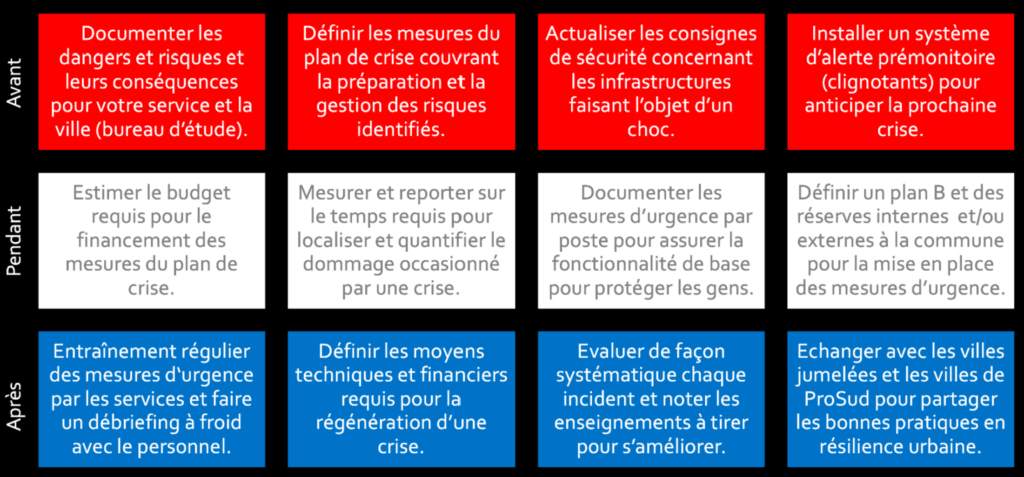
The Esch-sur-Alzette resilience strategy adopts a layered approach akin to an onion, focusing on fortifying the city’s resilience from its core outwards. This entails securing the reliability of technical services on the inside, strengthening citizen-facing services and ultimately prioritising the well-being of both residents and businesses. The plan is built around 12 concrete actions strategically divided into three phases: before, during, and after a crisis.

Before the Crisis: Proactive Preparation. Each city department will assess its vulnerabilities and craft departmental crisis plans. These measures will involve updating safety protocols for critical infrastructure and implementing early warning systems to anticipate potential crises.

During the Crisis: Effective Response. Measures include pre-allocated budgets for crisis response activities, efficient damage assessment protocols, and documented departmental actions to ensure basic functionality and public safety. Additionally, backup plans as well as external and internal resource mobilisation strategies shall ensure a robust response even in unforeseen circumstances.

After the Crisis: Learning and Rebuilding. Regular training exercises and post-crisis debriefings will equip city departments to continuously improve their response capabilities. A structured approach to evaluating incidents will identify valuable lessons learned. Finally, Esch-sur-Alzette fosters a collaborative approach by sharing knowledge and best practices with partner cities, strengthening regional resilience. The plan is to proceed in seven steps. This includes the appointment of a “Chief Resilience Officer”, the regular discussion of resilience plans in the individual community services, the creation of Smart City use cases of technological solutions for increased resilience and the sharing of the plan with the member municipalities of the syndicate ProSud.

Resilience Matrix (Source: Ville d’Esch: https://administration.esch.lu/2023/01/27/esch-pionniere-presente-son-plan-de-resilience/)

Outlook

As a living document, the Esch-sur-Alzette resilience plan will continuously evolve to meet future challenges. The city plans to share its insights and experiences with neighbouring municipalities to foster synergies in resilience-building efforts. Furthermore, ongoing initiatives such as Smart City projects will leverage cutting-edge technologies to further enhance the city’s resilience. This pioneering initiative positions Esch-sur-Alzette as a model for urban resilience, proactively building a more secure and sustainable future for its citizens and potentially inspiring other Luxembourgish municipalities.

Contact

Ville d’Esch – Urban Development Division: https://administration.esch.lu/intro-et-contact/

References

Communication of the city of Esch (French): https://administration.esch.lu/2023/01/27/esch-pionniere-presente-son-plan-de-resilience/

Presentation of the resilience plan (French): https://esch.lu/wp-content/uploads/2023/01/Presentation-Plan-de-resilience-Ville-dEsch.pdf

Newspaper article in tageblatt.lu (German): https://www.tageblatt.lu/headlines/velodukt-gratis-kurzzeitparkplaetze-und-ein-resilienzplan/

In October 2020, a significant milestone was achieved in the southern Luxembourg region, as 11 municipalities under the PRO-SUD syndicate joined the UNESCO Biosphere network, a label renowned as educational hubs for sustainable development. This move accelerates a series of initiatives aimed at actively fostering sustainable development.

One of the key initiatives that followed was the collaborative formulation of a “territorial vision” for the region, harmonised with the objectives outlined in the Luxembourgish National Territorial Development Plan (PDAT). The “territorial vision” strategy is taking shape with the Mission Zero Carbon – 11 municipalities for the ecological transition launched in April 2023 and marked by the signing of a Letter of Intent by PRO-SUD’s 11 municipalities, the Minister of Spatial Planning, and the Minister of Environment.

Aim

The primary goal of Mission Zero Carbone is to foster regional collaboration towards achieving carbon neutrality by 2050, in alignment with the Luxembourgish national territorial development plan (PDAT). To realize this ambition, a range of strategies has been identified, encompassing:

  • Reducing energy consumption: Advocating for energy-saving practices and technologies across public sectors.
  • Increasing renewable energy usage: Promoting the adoption and integration of renewable energy sources, such as solar panels.
  • Enhancing energy efficiency through regional energy planning.
  • Promoting sustainable mobility: Advocating for active transportation modes like cycling and walking and enhancing public transport infrastructure.
  • Safeguarding and restoring natural habitats: Ensuring the preservation of existing ecosystems and rejuvenating degraded areas to amplify their carbon sequestration potential.
  • Educational programs engage students, teachers, and cultural associations in the ecological transition, fostering active participation and awareness to drive sustainable change.

A first concrete project of this regional approach is the bioclimatic map launched in partnership with the Luxembourg Institute of Sciences and Technology (LIST) and Geonet by acquiring vital data and conducting precise analyses on the urban bio-climate of the region.

Concurrently, the Bioclimatic Mapping Project is committed to assessing the urban bio-climate in the southern Luxembourg region. The recommendations derived from this mapping effort will be closely associated with PRO-SUD’s involvement in the Cool Neighbourhood Interreg Northwest programme, which is designed to address urban heat challenges. This initiative marks a significant advancement in fostering the development of sustainable and resilient cities through meticulous data collection and analysis. The results will be publicly available towards the end of 2024.

The localisation of the UNESCO Minett Biosphere (Source: https://minett-biosphere.com/en/our-biosphere/)

Genesis and Composition

After the Luxembourg UNESCO Commission began discussing the first biosphere reserve in the Grand-Duchy in 2016 and followed by 4 years of multidisciplinary work to complete the application, the Minett region was officially recognized as such in October 2020, making Luxembourg part of the scientific Man and the Biosphere (MAB) programme. This programme promotes the conservation of biodiversity by engaging inhabitants, educating, researching, and supporting regional initiatives for sustainable development. The Minett Biosphere presents a fascinating juxtaposition: abandoned mines transformed into biodiversity havens, alongside ongoing human activity within dedicated transition zones. The Minett biosphere encompasses a region significantly impacted by iron ore extraction, leaving behind a distinct industrial legacy evident in its topography and cultural heritage.

PRO-SUD coordinated the application process and organized citizen consultations. Founded in 2003, the syndicate is a regional development union comprising 11 municipalities in southern Luxembourg. PRO-SUD, with the support of the Spatial Planning Department, is committed to promoting sustainable development in the region through various projects encompassing economic development, environmental protection, and social well-being.

Activities

The Minett UNESCO Biosphere advocates for biodiversity conservation and sustainable development, engaging citizens in educational efforts and research. It offers logistical assistance to projects focused on environmental education, multidisciplinary, regional and cross border collaboration with a commitment to fostering socio-culturally and environmentally sustainable economic and human development.

The post-industrial landscape of the region highlights the potential for ecological resilience, with diverse flora and fauna now flourishing in former mining sites. However, managing the delicate balance between environmental protection and ongoing growing human activity remains a huge challenge. To address this, the biosphere employs a strategic zoning system comprised of:

  • Core areas (zone centrale): Dedicated to research and conservation, strictly limiting human intervention.
  • Buffer zones (zone tampon): Surrounding core areas, these zones aim to minimize the impact of human activities.
  • Transition areas (zone de transition): Allow responsible human activities like agriculture and development.
The territory of the UNESCO Minett Biosphere (Source: https://minett-biosphere.com/en/our-biosphere/)

The territorial vision delineates a comprehensive developmental blueprint for the Minett region, encapsulating six pivotal objectives to ensure project alignment with overarching sustainable development objectives:

  1. Sustainable development: Pursuing a holistic approach that integrates environmental, economic, and social dimensions.
  2. Territorial cohesion: Mitigating socio-economic disparities across the region.
  3. Attractiveness and vibrancy: Augmenting the quality of life of residents and businesses.
  4. Ecological transition: Attaining climate neutrality and safeguarding biodiversity.
  5. Governance and participation: Advocating for participatory decision-making processes and citizen involvement.
  6. Resilience and adaptability: Anticipating and preparing for future challenges to ensure sustained regional viability.

The collaborative initiative, Mission Zero Carbone, epitomizes this vision, rallying the 11 municipalities within the Minett Biosphere towards achieving regional carbon neutrality by 2050. Each municipality formulates its action plan in alignment with the mission’s overarching objectives, addressing localized challenges and opportunities. Collaborative endeavours facilitate knowledge exchange, resource consolidation, and joint implementation of impactful projects across the region.

An initial project under this framework is the Bioclimatic Mapping initiative, generating pivotal data and analyses on the urban bio-climate of the Minett Biosphere. Initiated in response to a municipality architect’s request for more precise bioclimatic data to inform sustainable urban development strategies, this mapping project employs climate scenarios—specifically the RCP4.5 scenario—to project climatic conditions. Utilizing the 25th and 75th percentiles of temperature distribution (17.5°C and 19.5°C, respectively) instead of mean values, it offers a nuanced understanding of potential climate impacts.

PRO-SUD has commissioned the Luxembourg Institute of Science and Technology (LIST) to spearhead this project, leveraging diverse methodologies such as remote sensing, on-site measurements, and citizen science initiatives over an 18-month duration until the project’s conclusion in late 2024. The resultant data will inform the development of a comprehensive climate model for the region, guiding decision-makers in formulating effective emissions reduction strategies.

Outlook

Mission Zero Carbone represents a significant challenge, yet it is pivotal for the Minett Biosphere to attain its climate goals and contribute to the Territorial Vision.  he Bioclimatic Map, furnishing invaluable data and analysis, plays a crucial role in guiding strategic actions and ensuring the first mission’s success to develop regional collaboration between the 11 municipalities. For those interested in the UNESCO Biosphere in southern Luxembourg, the website provides insights into its initiatives for achieving climate neutrality and other impactful projects. Further information can be found on the Minett Biosphere’s website.

Contact

Gaëlle Tavernier: prosud@prosud.lu

References

Minett Biosphere: (English, French and German): https://minett-biosphere.com/en/

Mission Zero Carbone: (English): https://minett-biosphere.com/en/news/mission-zero-carbone-kick-off-meeting-3/

Vision territorial (French): https://minett-biosphere.com/lu/projects/vision-territoriale-3/

Project ClimProSud (English and French): https://www.list.lu/fr/recherche/projet/climprosud/?no_cache=1&tx_listprojects_listprojectdisplay%5Barchive%5D=&cHash=ac5bde4a60223253a34e3f5ad42ffb87 Analysing the Urban Bioclimate of the South (Project ClimProSud (English, French, German, Luxembourgish): https://minett-biosphere.com/en/news/analysing-the-urban-bioclimate-of-the-south/

Introducing Kuebebierg, a new urban development in Luxembourg’s Kirchberg area managed by the Fonds Kirchberg, focused on creating a sustainable and inclusive community. With an emphasis on environmental responsibility, social diversity, and economic viability, Kuebebierg aims to set a benchmark for future urban projects. From promoting alternative transportation to supporting local agriculture, Kuebebierg offers a balanced approach to urban living that prioritizes harmony with nature.

Aim

The aim of the Kuebebierg project is to create a vibrant, environmentally conscious neighbourhood that promotes sustainable living, social inclusivity, and economic vitality. Through careful planning and implementation, the project seeks to establish Kuebebierg as a model for future urban developments, both locally and internationally.

Aerial view of the planned neighbourhood (Source: Güller Güller Architecture Urbanism)

The Kirchberg quarter located on the north-eastern plateau of Luxembourg city is the vibrant business district, hosting not only banking and financial organisations but also EU institutions. The Fonds Kirchberg, established in 1961, operates under the supervision of the Minister of Mobility and Public Works and is responsible for urbanisation and development of the Kirchberg Plateau. It manages its operations and investments independently, relying on proceeds from real estate activities. Its main tasks include construction, urban development, and road infrastructure, with a current focus on building affordable housing. The Fund utilizes leasehold and other rights for land development, emphasising sustainability and community involvement in its planning processes.

The Fonds Kirchberg launched a competitive consultation process to develop an urban design charter establishing objectives for the landscape of the Kuebebierg area, a major land reserve belonging to the public organisation. The 33-ha area is located in a so-called deferred development zone (zone d’aménagement différée, or ZAD). The winning team of the consultation process presented its project in March 2022. The consortium is led by the Güller Güller Architecture Urbanism office in Rotterdam and Zurich, cooperating with Zeyen+Baumann, Atelier Alfred Peter, Etienne Ballan, Cabane Partner, RR&A, ZEFCO, Ecolor, Ville en Œuvre and Belvédère.

Illustrated plan of the Kubebierg neighbourhood (Source: Güller Güller Architecture Urbanism)

Activities

With its circular design and ecological focus, Kuebebierg aims to create a vibrant, liveable community that integrates seamlessly with its surroundings. Activities within the neighbourhood are guided by a holistic vision that embraces the area’s natural and urban characteristics, prioritising principles of sustainability and community well-being.

  1. Promoting Active Mobility: Kuebebierg prioritises diverse mobility options to reduce reliance on individual cars. Direct and secure routes for pedestrians and cyclists are integrated, along with the commissioning of a new tram line to enhance public transport accessibility.
  2. Limiting Car Circulation: With only one vehicle access point and a ratio of 0.5 cars per dwelling, Kuebebierg encourages a shift away from car-centric urban planning. Shared spaces accommodate various modes of transportation, fostering a safer and more vibrant urban environment.
  3. Creating Vibrant Public Spaces: The heart of Kuebebierg features a bustling square, reminiscent of traditional city centres, offering a diverse mix of shops, restaurants, and recreational amenities. These vibrant public spaces serve as focal points for social interaction and community engagement. A linear park and the tram line will connect public spaces, crossed by the spaces “Porte Frieden” and the “Place du Kuebebierg”.
  4. Maximising Renewable Energy Production: Kuebebierg embraces energy efficiency by prioritising renewable energy sources. From efficient building design to on-site energy production and storage, the district aims to minimise its carbon footprint while ensuring optimal living conditions for residents.
  5. Fostering Social Diversity: With a balanced mix of housing typologies and amenities, Kuebebierg promotes social inclusivity and diversity. Affordable housing options, coupled with accessible public services and recreational facilities, create an environment where people from all walks of life can thrive.
  6. Living circularity: the planned programme for the site, the architecture and the infrastructures are all aiming for a high standard regarding carbon footprint, local consumption and low energy demands, etc. In this context, the concept includes for example an urban farm and gardening.
  7. Farming in the City: The city farm project aims to maintain agricultural activity on one of the last remaining sites on the Kirchberg Plateau worked by farmers. It promotes biodiversity through more extensive green space management and offers multifunctional farming activities, including grazing, market gardening, and agro-tourism, contributing to economic, environmental, and socio-cultural services within the community.
Place du Kuebebierg (Source: Güller Güller Architecture Urbanism)

Status of Implementation

The implementation of the project started in 2022. At the western tip of the district, where the city farm and orchards are also planned, initial work began at the end of 2023 (planting trees and exploratory drilling for geothermal energy). This part of the district will also be included in the exhibition LUGA – Luxembourg Urban Garden taking place in 2025.

Onsite photo (Source: Fonds Kirchberg)

Outlook

The winning project for Kuebebierg embodies a vision of urban living in harmony with nature. By integrating topography and green spaces, creating pedestrian-friendly environments, and prioritising sustainability, Kuebebierg sets a new standard for future urban developments.

As construction progresses, Kuebebierg aims to become a living testament to the possibilities of sustainable urban planning. The aim is to achieve a district development plan for 2025, build infrastructure in 2027 and initiate the construction of housing in 2029. With its innovative approach and commitment to environmental and social well-being, Kuebebierg represents not just a neighbourhood but a vision of a more sustainable, inclusive, and resilient urban future.

Contact

Fonds Kirchberg: info@fondskirchberg.lu

References

Fonds Kirchberg (French): https://fondskirchberg.public.lu/fr/concepts-urbains/quartiers-futur/kuebebierg.html

Communication of the Luxembourgish government (French): https://gouvernement.lu/fr/actualites/toutes_actualites/communiques/2022/03-mars/02-urbanisation-terrains-kuebebierg.html

Paperjam article (French): https://paperjam.lu/article/kuebebierg-quartier-tourne-ver Record of the project presentation (French): https://www.youtube.com/watch?v=G56wT-yC8mw&t=38s

The Master Programme for Spatial Planning in Luxembourg, known as “Programme directeur d’aménagement du territoire” (PDAT) 2023, is the central element of the country’s spatial planning policy. Serving as a framework for a sustainable development of the national territory and for enhancing the quality of life of all citizens, the PDAT defines an integrated strategy for sectorial policies with a territorial impact and defines guidelines, objectives and measures for the government and municipalities. The newly adopted PDAT (21 June 2023), which was prepared by the Department of Spatial Planning in cooperation with an interministerial working group, builds upon a large public participation process in 2018 and the international consultation “Luxembourg in Transition” in 2020—2022.

Structure and objectives

PDAT 2035 (Source: Département de l’aménagement du territoire (DATer) 2023)

In order to frame the strategy, objectives and measures, the PDAT was developed in accordance with the following four guiding principles:

  • Increasing the resilience of the territory
  • Safeguarding territorial, social and economic cohesion
  • Ensuring a sustainable management of natural resources
  • Accelerating the transition of the territory to carbon neutrality

Based on those guiding principles, three policy objectives and a cross-cutting objective have been identified, addressing the development issues highlighted in the spatial analysis as well as the challenges imposed by climate, environmental, geopolitical and health crises:

1. Concentration of development in the most suitable places: Central to the PDAT’s mission is guiding sector policies and supporting municipalities in locating essential functions and services in the most suitable places. This aims to facilitate access to services, anticipate and reduce mobility needs as well as plan for critical infrastructure.

By guiding future development, the PDAT enables efficient infrastructure planning and a cost-effective implementation of sector policies. The territorial strategy encompasses an urban hierarchy based on Central Places (centres de développement et d’attraction, CDA), which is supposed to steer the spatial distribution of population (i.e. development) and employment growth (i.e. attraction) in a sustainable manner.

2. Reducing land take: The PDAT focuses on limiting the process of converting natural, agricultural or forest land into built-up areas. Decreasing land take offers several benefits, including mitigating the effects of climate change, preserving natural and semi-natural areas, minimising flood risks, protecting biodiversity, and fostering carbon sequestration. The goal is to gradually reduce land take from by 2035 and tend towards no net land take (zéro artificialisation nette du sol) by 2050.

Dynamics of soil artificialisation 2007-2018 (Source: Département de l’aménagement du territoire (DATer) 2023)

To achieve this, the PDAT puts forward a planning culture that promotes urban regeneration, multifunctionality and efficient land management.

3. Cross-border spatial planning: Taking into account the functional linkages between Luxembourg and its cross-border functional region, the PDAT recognises the need for a concerted territorial development in the Greater Region (Grande Région). To address ecological and climate transition challenges, the Master Programme promotes territorial development strategies for cross-border functional areas, consultation with neighbouring regions in the framework of planning processes, and cross-border resource management.

4. Collaborative Governance as a cross-cutting objective: In the PDAT, governance is considered to be a cross-cutting objective, emphasising the coordination required for effective spatial planning. This is meant to happen horizontally across sector policies, vertically between the State and municipalities, as well as through public participation.

Time Horizon

The PDAT2023 is meant to unfold in two phases: 2023-2035 and 2035-2050. The first period until 2035 will act as a transition phase, which contributes to reversing the current development trends. Actions will focus on identifying and adopting instruments for the implementation of the Master Programme as well as initiating pilot projects and stakeholder connections.

The second phase, from 2035 to 2050, will ensure a steady transition and reverse the trends in question by the implementation of the strategies, while monitoring the developments as well as adapting approaches as needed.

Programme directeur d'aménagement du territoire 2023 - Stratégies  territoriales - Portail de l'aménagement du territoire - Luxembourg
Vision 2050 in the PDAT (Source: Département de l’aménagement du territoire (DATer) 2023)

Implementation

In order to achieve the above-mentioned policy objectives in the given timeframes, two territorial strategies have been developed at different scales. First, the national territorial development strategy “Leitbild 2050” envisions a carbon-neutral and resilient territory, emphasising green, yellow and blue networks, the concentration of development in accordance with the urban hierarchy, and a sustainable mobility. This national territorial development strategy has also been broken down to so-called action areas (espaces d’action) at a functional-regional level. In this context, territorial visions for the three urban agglomerations have also been developed. Second, the territorial development strategy at the level of the Greater Region promotes cooperation in cross-border action areas, in accordance with the Interreg VI Greater Region programme. This cooperation fosters integrated territorial development in cross-border functional areas, complementing previous approaches by addressing challenges linked to the environment and natural resources. The implementation of strategies will be fostered through the adaptation of existing regulatory instruments and the potential creation of new ones.

Conclusion

The Master Programme for Spatial Planning in Luxembourg sets a forward-looking and ambitious territorial vision. By addressing climate change, resource preservation and sustainable growth, the PDAT paves the way for the ecological transition of the territory. Through clear strategic objectives and cross-sectoral coordination, Luxembourg is taking a further step towards sustainable development and enhancing citizens’ quality of life.

References

Master Programme for Spatial Planning in Luxembourg – “Programme directeur d’aménagement du territoire” (PDAT) 2023 (French): https://amenagement-territoire.public.lu/content/dam/amenagement_territoire/pdat-programme-directeur-damnagement-du-territoire-4072023.pdf

Spatial planning portal (French): https://amenagement-territoire.public.lu/fr/strategies-territoriales/programme-directeur.html

“Luxembourg in Transition” (LiT) can be characterised as an innovative process with the aim of rethinking and reshaping the territorial transition of Luxembourg and its neighbouring regions across the border by developing visions for a desirable future until 2050. The territorial visioning approach is innovative in the sense that it goes beyond traditional planning culture and instruments in an interdisciplinary manner and the spirit of coopetition.

Aim

The main objective of this innovative process is to develop different territorial visions, based on ecological transition scenarios, strategic spatial planning solutions and demonstration projects, for a decarbonised and resilient cross-border functional region of Luxembourg until 2050. The ecological transition refers to achieving the objectives of zero carbon emission while:

  • reducing land take;
  • enhancing biodiversity, improving ecosystem quality;
  • integrating the aspects of housing, transport, energy and digitalisation;
  • creating concepts and models for a territory resilient to climate change;
  • promoting an economic development that is stable, equitable and solidarity-based; and
  • strengthening territorial and social cohesion.

The territorial visions are based on the long-term horizon of 2050. By comparing the visions with the business-as-usual scenario, it becomes possible to identify the changes required for achieving the objectives and design a roadmap.

source: Luxembourg in Transition, 2020: Logo

Partnership

The LiT process was initiated by the Department of Spatial Planning of the Ministry of Energy and Spatial Planning. The consultation was accompanied by different committees: The Scientific Committee provided expertise from research and planning practice; the Advisory Committee incorporated the interests of partner and stakeholder organisations from Luxembourg and the Greater Region; the Interministerial Committee engaged all relevant sector ministries and steered the process; and the Citizens’ Committee (Biergerkommitee Lëtzebuerg 2050) introduced the population’s perspective and addressed recommendations to political decision-makers. An external service provider was tasked with the scientific management of the process and overseeing the work of the expert teams.

Activities

The international consultation within the framework of the LiT process was designed as a three-stage cooperative competition (“coopetition”), aiming to engage international experts from various disciplines and stimulate cross-fertilisation among teams. The consultation brought together practitioners, universities and other research organisations and gathered knowledge in the fields of regional and urban development as well as architecture, environmental and social sciences. The initial ten teams started working in October 2020 and the four final teams presented their results in January 2022. The three stages of the consultation aimed to refine and concretise the so-called “transition visions” developed in each preceding phase.

Stage 1: In this stage, the expert teams were tasked with developing a quantitative approach to assess the effectiveness of measures in reducing greenhouse gas emissions. The metrics needed to quantify various aspects related to land use, energy consumption, waste management, food production, water resources or biodiversity.

Stage 2: Building upon their work in Stage 1, the expert teams were required to apply their metrics to the territory and show how innovative concepts in spatial planning could be implemented. The focus was on the cross-border functional region of Luxembourg, exploring the potentials and challenges of implementing measures in a cross-border context.

Stage 3: The final stage called for the expert teams to develop concrete strategies and exemplary projects to anchor the vision both within Luxembourg and across borders. This stage emphasised topics such as energy efficiency, the protection of biodiversity, resilience and climate change adaptation, resource scarcity and food security.

University of Luxembourg et al., 2021: Representation of a converted commercial area

For instance, the team led by the University of Luxembourg presented measures for regenerating industrial parks and commercial areas through conversion, multifunctional usage, the use of local products and renaturing. The experts developed their vision using the example of the commercial area Foetz in Mondercange, Luxembourg.

Further projects and detailed information about the entire LiT process can be found on the website: https://luxembourgintransition.lu/en/

Outlook

The LiT process represents an innovative approach to shaping the future of Luxembourg. By engaging a diverse range of actors, implementing a multi-stage competition, and incorporating cross-border aspects, the process aims to develop a sustainable and resilient Luxembourg in a sustainable and resilient manner. The vision’s long-term horizon of 2050 provides a framework for setting goals, identifying necessary changes, and establishing a roadmap for this development. The next step is to shift from theory to practical implementation, which consists of pilot projects and demonstrating the ability of the functional region Luxembourg to transition towards a carbon-free territory. Additionally, the transferability and application of the LiT process in other territories – cross border or not – is illustrated in the Guidance Note “Cross-Border Spatial Planning: A vision for a cross-border functional region” which is a Pilot Action of the Territorial Agenda. It demonstrates the applied methodology and discusses the implications of decarbonisation and sustainability for spatial planning and its cross-border dimension. Find out more about the pilot action here: https://territorialagenda.eu/pilot-actions/cross-border-spatial-planning/

Contact

Luxembourg in Transition: https://luxembourgintransition.lu/en/contact-2/

References

Esch-sur-Alzette is the second largest city of Luxembourg and has a rich industrial heritage. Not least because of this heritage, the city is currently undergoing a significant transformation. At the forefront of this process is the visionary project Rout Lëns. Aimed at revitalising a former industrial site, Rout Lëns is set to become a sustainable and socially vibrant neighbourhood.

Aim

Population projections estimate that by 2050, the city of Esch will almost double to 220,000 inhabitants. To meet this growing demand, new infrastructure is needed. Rout Lëns fits this dynamic perfectly. The project will revitalise a disused industrial site of 10.5 h and transform it into a sustainable and liveable neighbourhood. The overall objective is to create a harmonious balance between urban development, community engagement, and environmental sustainability. The project seeks to develop a vibrant, inclusive, and environmentally conscious space where residents can live and work. In addition, the neighbourhood is being developed in the sign of social and intergenerational diversity. The visionary approach pursues the following objectives and aims to create:

  • A strong territorial identity: building a strong community aligned with the industrial heritage and rehabilitating it.
  • A simple and fluid daily life: enabling a dynamic and convenient life for residents through technological innovation, soft mobility and logistics.
  • A territorial, human and cultural link: encouraging initiative by connecting people and different users of the space such as residents, visitors, employees, shop owners and neighbours.
  • A resilient neighbourhood: creating a sustainable community and space with high adaptability to challenges and changes.
Copyright: IKO Real Estate, 2023

Partnership

The Rout Lëns project is driven by the collaboration of various stakeholders and in close cooperation with the municipality. IKO Real Estate leads the project, supported by the architecture-urbanism agency Reichen et Robert & Associés, along with the landscaper Agency Phytolab. For the first two buildings Tatiana Fabeck and Carta Reichen and Robert & associés were contracted. The participatory process is guided by CityTools, an agency specialised in sociological and urban planning projects that incorporate local community input. This partnership ensures that the development of Rout Lëns remains aligned with the needs and wishes of its future inhabitants. Furthermore, the project is aligned with the Luxembourg government’s sector plan for housing, and the city of Esch-sur-Alzette has acquired almost 300 housing units, ensuring that 30% of the housing in the new district will be affordable housing.

Activities

The implementation of the project follows four founding pillars:

  • The urban structure – Industrial Culture Alley: The “Allée de la Culture Industrielle » will be a pedestrian route linking the five industrial heritage facilities which have become user-friendly, multifunctional places (Magasin TT, Halle des Turbines, Halle des Soufflantes, Portique de la Mollereï et Poste d’Aiguillage).
  • The built form – A stratified neighbourhood: a variation of building height will give multifunctionality to each stratum and diversity of uses such as hanging gardens, urban gardening, terraces, unobstructed views and a different atmosphere at each level of altitude.
  • The place of nature – A vegetal feeling: The masterplan of Rout Lëns prioritises well-being and nature in the real-estate project by e.g. planting almost 700 trees in the district.
  • A sustainable & innovative neighbourhood: the district will be adjusted towards innovation in terms of sustainable mobility, architecture, urban development, and energy supply consumption including waste management, urban farming and circular economy approaches.
Copyright: IKO Real Estate, 2023

The development of Rout Lëns is a participatory process that actively involves the local community. Through surveys, workshops, and consultations, residents and stakeholders had the opportunity to contribute their insights, ideas, and concerns during the first phases and will continue during its further implementation. This inclusive approach empowers the community to shape the future of their neighbourhood, fostering a sense of ownership and local identity.

The project includes housing of all sizes, from studios to flats with 1 to 4 bedrooms, including low-cost accommodations. The integration of affordable housing supports the project’s aim of creating a high degree of social mix within the neighbourhood. Although 81% of the area is dedicated to housing, it will not be only a residential neighbourhood since other uses will be included, such as schools, community and public services, shops and private services as well as offices and shared workspaces.

Copyright: IKO Real Estate, 2023

The Well Community certification guarantees that all buildings developed in Rout Lëns meet high-quality standards, focusing on the well-being of the residents. The certification prioritises air and water quality, natural light sources, and overall physical and psychological comfort. The incorporation of green spaces, including an urban forest, flower-filled meadows, and small habitats, will enhance biodiversity and provide pleasant environment with high quality of stay.

Copyright: IKO Real Estate, 2023

Soft mobility solutions will be prioritised to encourage sustainable transportation options, such as walking, cycling, and public transportation. A comprehensive network of shared mobility services, cycle paths, Bus Rapid Transit (BRT) and a high-speed tram line will ensure convenient accessibility to and within the neighbourhood. The connectivity and spatial planning are designed to align the new neighbourhood with surrounding residential areas and extend the city centre instead of depicting any competition for the rest of the city. In addition to that, the district is planned to be carbon-footprint-neutral and will try to recover grey water (wastewater from showers and sinks) and it will be supplied with geothermal energy. You can learn more about the energetic concept of the project in the first session of the CIPU lecture series from May 2023. You can find the recording here: https://www.youtube.com/watch?v=G88Gm22oHy4

Copyright: IKO Real Estate, 2023

The district will be constructed in three phases. The Eastern part will be constructed from 2024-2029, followed by a transition phase in 2028 resulting in construction phase 2 and 3 from 2030-2033. This way, certain sectors will be functional and habitable before the whole neighbourhood will be finished in 2035.

The new school. Copyright: Tatiana Fabeck, 2022

Outlook

Rout Lëns is a transformative project that envisions a sustainable, resilient, and socially inclusive neighbourhood in Esch-sur-Alzette. By combining innovative design, community engagement, and environmental management, Rout Lëns is set to revitalise the former industrial site into a liveable urban space. The project’s commitment to open-mindedness, innovation, inclusion and heritage is reflected in the four pillars of its vision. The realisation of Rout Lëns as is good practice of revitalising an industrial site and creating a sustainable and innovative urban space aligned with its heritage.

If you want further information and get a glimpse at how the district is going to look like, you can find more information, maps and visual material on the official website where you can also subscribe to the newsletter.

Contact

Rout Lëns: info@routlens.lu

IKO Real Estate: communication@ikorealestate.eu

References

https://iko.virtualbuilding.fr/iko-routlens/le-quartier

The “National Platform for Urban Policy” (CIPU) enables cooperation between national, regional/intermunicipal and local level and initiates the debate around urban planning and development in Luxembourg. In addition to that, it raises awareness in the international context and informs about ongoing urban spatial planning trends and relevant topics in Luxembourg.

Aim

CIPU works on two levels: the European and the national level. While increasing awareness about spatial planning in Luxembourg in the international context, the platform simultaneously supports the cooperation between the local and the national level in Luxembourg. The central objective of CIPU has always been to provide a platform for exchange between the various urban policies and a multitude of municipal, national and European actors and enable cooperation – an objective which remains valid today. However, the practical topics have evolved across the years. The convention applies a focused and cooperative approach for its implementation.

Partnership

CIPU is based on an agreement between the Luxembourg Ministry of Energy and Spatial Planning, the Ministry of Housing and Ministry of Home Affairs as well as the cities of Luxembourg, Esch-sur-Alzette, Differdange and Dudelange. These partners constitute the core network of the CIPU. It is managed and organised by the CIPU which is run by Zeyen+Baumann in cooperation with Spatial Foresight. Depending on the subject, the platform’s activities are implemented in close cooperation with external partners, e.g. the Klima-Agence.

Patty Neu, November 2019: Presentation of CIPU publications during the press conference in November 2019, Claude Turmes, Minister of Energy and Spatial Planning and Henri Kox, Minister of Housing

Genesis

CIPU was developed in 2010 to support the integration of the recommendations for urban development from the European level in Luxembourgish spatial planning policy. In Luxembourg, the debate on spatial development since the beginning of the 2000s has been marked by the adoption of the second Master Programme for Spatial Planning (PDAT) in 2003, the Integrated Transport and Territorial Development Concept (IVL) in 2004 and the revision of the laws on urban (2004) and spatial planning (2013, 2018). CIPU initially aimed at transposing the objectives from the “Leipzig Charter on Sustainable European Cities” from 2007 at the national level while involving Luxembourgish municipalities in the implementation of a national urban policy, and – at the same time – considering the objectives of the PDAT which has a guiding function for national and local authorities.

Zeyen+Baumann, September 2021: CIPU excursion on Revitalising city centres in September 2021

During 2017-2021, a thematic focus was set for each year: In 2017/2018 the activities were focused on affordable housing. The year 2019 revolved around the topic of major urban development projects, the years 2020/2021 focused on both climate change adaptation in urban development and the revitalisation of inner cities. Furthermore, in the course of 2021, CIPU addressed the changing framework conditions caused by the COVID-19 pandemic and work was carried out under the overarching title “City in Transition”. In addition to workshops and events, which were dedicated to concrete issues and enabled a direct exchange between the participants, the results of the discussions were processed in numerous publications for Luxembourgish and European planners. These were produced in close cooperation with the partners involved in the CIPU and the actors participating in the workshops. The CIPU documentation is thus a significant output that actively contributes to informing and developing the expertise of Luxembourgish planners. In order to finalise this phase of CIPU and to provide space for other important topics in the future, the “Journée de la Politique Urbaine” was organised with Luxembourgish planners and experts in January 2022. In a world café-like setting, the future perspectives for a “City in Transition” were elaborated as a summarizing statement of the CIPU 2020/2021.

Patty Neu, October 2019: CIPU workshop on innovative urban development projects in October 2019

Outlook

The main topics and activities for the next two years are described in an ambitious programme. It was developed in close cooperation with all involved partners by means of in-depth discussions about relevant topics. This action programme will cover the following topics:

  • multifunctional urban areas
  • energy concepts for large-scale urban projects
  • climate resilience and climate change impact in urban development
  • building cooperatives and alternative models for housing and working

Activities for 2023 were launched in May with the online lecture series (colloque) consisting of four presentations on energy concepts in the district “Roud Lëns”, the projects “NeiSchmelz” and “Wunne mat der Wooltz” as well as the energetic renovation of existing buildings in Differdange and a low-emission district in Strasbourg. Further steps in the implementation include interactive thematic workshops, an excursion and a concluding conference on the second thematic focus of multifunctional urban areas. For external communication, and awareness-raising, CIPU will inform about ongoing activities, publications and provide a collection of funding opportunities for municipalities on its website and social media. Furthermore, this blog will inform continuously about ongoing urban planning and development trends and projects in Luxembourg – so stay tuned during the next months.

Contact

Cellule nationale d’Information pour la Politique Urbaine (CIPU): cipu@zeyenbaumann.lu

References

CIPU website (German and French): https://site.cipu.lu/

CIPU blog (English): https://blog.cipu.lu/blog/

Conclusions of CIPU 2020/2021 (German): https://site.cipu.lu/images/2022-03_publications2022/CIPU_Conclusions%202020-2021_2022-03-30.pdf

Frequent extreme weather events in Luxembourg in recent years have pushed climate change higher up the public agenda. The call for more public action has become louder in view of the devastating effects of recent tornados and torrential rainfall, followed by flooding and extended drought in the summer noticed by residents and visitors.

Preparing and adjusting to current and future effects of climate change, ‘climate change adaptation’, is one pillar next to climate action that governments around the globe are working on to limit the impact of climate change on societies.

Despite progress made during past years, there are critical gaps in implementation of climate action, where policy ambitions have not yet yielded necessary action. This highlights the need for clear information and guidance to streamline actions to progress towards a shared agenda for practitioners and planners. The ‘Climate Change adaptation strategy’ comprehensively promotes climate change adaptation in Luxembourg.

Rationale for action

According to IPCC scenarios, by the end of the 21st century, Luxembourg will experience today’s climate of Milan. What sounds positive at first glance has serious consequences with average annual temperature rising from 8.8 to 13.1° Celsius and rainfall increasing by 30% over the next 80 years.

These numbers should not distract attention from expectations of more frequent extreme weather events including heat stress, rainfall variability, less available freshwater, lower crop yields, lower soil quality, uncertain energy supply, increasing conflicts of use and less biodiversity. These show the current system is not yet ready to cope with climate change.

Despite these observations, climate change adaptation still appears to be a side note in Luxembourg spatial planning. With municipalities responsible for planning, state institutions depend on municipal decision makers and planners being informed and willing to work towards climate change adaptation. To become more resilient to a changing climate, more attention needs to be given to climate-change adaptation to prepare for inevitable impacts as the current system is not yet prepared.

Objective

Preventing harm to humans and natural ecosystems from climate change requires adapting the built environment. The fundamental assumptions on which local planning and developments have been based for decades have changed, especially for water availability and amount of rainfall.

Much more than simple adaptations are necessary. With changing fundamental assumptions on climate, new techniques and methods are needed. This means new methods to cope with the new reality and to adapt existing systems.

Transition is very complex. It requires modifications to the way we have planned for decades. So planning guidance is essential, along with a national reference framework to detail and measure the effectiveness of actions to induce significant change. The Climate Change Adaptation Strategy provides this guidance. It gives information from Luxembourg planners for Luxembourg planners about climate change adaptation.

Time frame

The strategy has been updated frequently since the first edition in 2012. New planning laws and regulations made an update necessary in 2016 and a new edition was published in 2018 which remains valid today. To assist local decision makers and planners, the new edition also has an implementation strategy.

Key players

The strategy has been developed by the Department for Environment of the Luxembourg Ministry of Energy and Spatial Planning, which is also responsible for implementation. It works towards the Paris Agreement and has been adopted by the Government so it applies to all government institutions.

Cover page of the C-Change strategy. Source: MEV, 2021.

Implementation steps and processes

The climate change adaptation strategy offers a comprehensive catalogue of measures. It covers construction and housing, energy, forestry, infrastructure, civil protection, spatial planning, agriculture, human health, ecosystems and biodiversity, tourism, urban development, water management and the economy. There are also specific recommendations on cross-cutting measures.

There are several measures for each topic and every measure is described in a factsheet. These detail the objective, the type of measure, necessary steps, additional information, stakeholders and success indicators.

With the detailed factsheets, the strategy also offers guidance and information on responsibilities. Municipalities can identify measures based on the desired effects of their actions.

Required resources

The resources used to create the strategy are not known.

Results

The strategy has been developed in a participative process, involving municipal and national planners. Recommendations respect the national and local planning regulations.

Every recommendation is explained in a table format (see below). It comes with a detailed description, ensuring that a measure follows the climate change adaptation strategy. Key stakeholders to implement recommendations are also detailed.

Despite the comprehensive guidance, measures still need to be translated into the local context by municipalities. This ensures that decisions respect local specificities. It also ensures municipal planning autonomy, a valuable commodity in the Grand Duchy.

The strategy has been adopted by the Luxembourg Government. All public institutions are asked to consider the document in the planning of public projects.

Example of a recommendation in table format from the strategy. Source: MEV, 2021.

Experiences, success factors, risks

Adapting spatial planning to climate change is a difficult task. The strategy contains much useful information for planners and experts, helping to inspire national and local action.

Conclusions

The strategy is a reference document for climate change adaptation from 2018 to 2023. After 2023 it will be revised and updated again, to incorporate new knowledge and new planning legislation.

Contact

Contact: https://environnement.public.lu/fr/support/contact.html

References

Ministry of the Environment, Climate and Sustainable Development, Strategy and action plan for climate change adaptation:

German: https://environnement.public.lu/content/dam/environnement/documents/klima_an_energie/Anpassungsstrategie-Klimawandel-Clean.pdf

French: https://environnement.public.lu/content/dam/environnement/documents/klima_an_energie/Strategie-Adaptation-Changement-climatique-Clean.pdf

Many firms and jobs in the Grand Duchy of Luxembourg are centred around the capital city. Municipalities beyond Luxembourg city and its immediate surroundings have difficulties attracting firms and providing local employment. In addition, the many international companies in Luxembourg mean that prices for office space are challenging for start-ups.

The municipality of Dudelange in the south of the country has initiated ‘Innovation Hub Dudelange’. This incubator is a first step to supporting a new eco-innovation cluster within the municipality and providing affordable office space for start-ups.

Rationale for action

With an ever-increasing number of enterprises and jobs around the capital city, some recent developments have caused difficulties, including the many cross-border commuters working in Luxembourg city. Territories between Luxembourg city and the borders to Belgium, France and Germany have turned into a ‘drive-through country’. With a low municipal business tax rate, Luxembourg city continues to be an unrivalled player in the competition for businesses in the Grand Duchy, leaving little chance for other municipalities to attract firms.

Many international firms rent offices in Luxemburg city, so it has become difficult for start-ups to find affordable office space in the capital area. Start-ups often rely on cheap office space, so where space is expensive less of them can emerge.

Objective

The ‘Dudelange Innovation Hub’ aims to attract and support eco-technology start-ups that will help to establish a new economic cluster in the municipality and the country. Eco-technology approaches, practices and technologies developed in the new cluster can eventually be transferred to municipal departments to improve their services.

This will contribute to local economic development and new jobs. The incubator also aims to shape economic activities towards sustainable and ecological activities in the future ‘NeiSchmelz’ eco-district, a brownfield development within the municipality.

Time frame

The decision to set-up ‘Dudelange Innovation Hub’ in the ‘NeiSchmelz’ district was taken in July 2017. Two months later, the project was presented to the public. With support from several national players, implementation of facilities for the incubator started soon after. In July 2018, just one year after the decision was taken, the incubator opened its doors and welcomed the first enterprises. In 2019, the Incubator welcomed seven start-ups. Three start-ups cooperated closely with the municipality for testing and introducing their products and services in the city of Dudelange.

Key players

‘Innovation Hub Dudelange’ is an initiative of the municipality which chairs and administers the incubator. The provision of facilities and their operation is in cooperation with national players, namely Luxinnovation and Technoport S.A. This innovation agency and business incubator assist the municipality in selecting businesses. Another player is the ‘Fonds du Logement’, the national fund for housing, which owns the land.

Implementation steps and processes

The availability of financial and organisational resources required for the project and the limited number of players involved meant progress on ‘Innovation Hub Dudelange’ was quick. The concept was developed and approved in 2017 and the incubator started operation in July 2018.

Operation of the incubator is ensured by the municipality together with the national innovation agency and the national technology incubator. Start-ups looking to rent office space apply to the national innovation agency. After a pre-selection, a final choice is made by a selection committee of all three key players.

Once the start-ups are welcomed in the ‘Innovation Hub Dudelange’, they receive support in the form of contact building, fundraising and other services provided by the national innovation agency and the business incubator.

Required resources

The municipality rents office spaces from the national fund for housing ‘Fonds du Logement’. In addition to the rent, implementation of the facilities cost EUR 175,000, which was covered up to 80 % by the state.

Results

‘Innovation Hub Dudelange’ includes 14 furbished offices available to eco-technology start-ups. Additionally, the 500 square meters of newly built office space include conference rooms and shared facilities.

Companies can rent the offices for up to five years at a reduced rent. Start-ups less than two years old pay EUR 15 per square meter each month, all other companies pay EUR 20.

At the end of 2019, one year after inauguration, seven of the 14 workplaces were already let. The start-ups cover specialisations including smart irrigation systems, smart LED street lighting systems and active mapping of flood zones using innovative drone technology. Products of these eco-technology firms are transferred to the local administration and will improve the public services provided by the municipality.

Facilities of the ‘Innovation Hub Dudelange’. Source: Municipality of Dudelange, 2018.

Experiences, success factors, risks

‘Innovation Hub Dudelange’ is an innovative approach offering start-up support to a specific sector in a specific location. The instrument also helps to foster innovation in eco-technology. Although this is frequently in the media, it is not frequently addressed by entrepreneurs.

The instrument is also suitable for interim uses. While the eco-district is developing at full speed, ‘Innovation Hub Dudelange’ was based in a building of a steel mill that halted production in 2005. Occupation of the offices by start-ups is for up to five years, so winding-up the incubator should involve little effort when the services are no longer needed.

Conclusions

‘Innovation Hub Dudelange’ shows that relatively little finance is required to set-up a business incubator. Such initiatives are thus suitable for smaller municipalities with limited human and financial resources. Relying on support from national agencies, the municipality benefits from local economic development incentives from the start-ups as well as from the emerging eco-technology cluster, enabling innovations to be transferred to the municipal administration.  

Contact

Contact address: innovationhub@dudelange.lu

References

Municipality of Dudelange, 2019: ‘Innovation Hub – 3 startups réinventent la ville de demain avec Dudelange!’ (in French):

Luxinnovation, 2019: News – Innovation Hub – one year of supporting eco-technology: https://www.luxinnovation.lu/news/innovation-hub-one-year-of-supporting-eco-technology/

Urban garden and horticultural shows have a long tradition in Europe. Many countries organise them, notably France with ‘Villes et Villages Fleuries’ (flowering cities and villages) and Germany with ‘Bundesgartenschau’ and ‘Landesgartenschau’ (federal and regional garden show).

Parks and green areas are created or refurbished to accommodate temporary exhibition areas. These spaces increase the attractiveness of cities and the well-being of residents. In 2025, an urban garden show will cover the whole of Luxembourg.

Rationale for action

Luxembourg has a long tradition in horticulture and related sectors. One is food production that yields a large range of niche products and producers as well as a well-developed local market which currently lack public recognition. An example is the long tradition of rose-growing in the country.

Objective

The Luxembourg Urban Garden show (LUGA) was launched to draw the attention of residents and tourists to the ‘green economy’ in Luxembourg. Appreciation for green jobs and local production will be increased by highlighting production methods, products and their historic and cultural importance. In addition to promoting the agricultural and horticultural sectors, it will also showcase ecological planning in the city of Luxembourg.

Cover image of the ‘Urban development nature’ topic. Source: LUGA – Luxembourg Urban Garden.

Time frame

Back in 2011 the idea for a horticultural show came up, which led to pre-studies and concept development. The LUGA will be held from May to October of 2025 but, as with other garden shows, the changes will be longer lasting, increasing the attractiveness of the city.

Originally, the garden show was planned for 2023. Because of the restrictions imposed in response to the COVID19 pandemic, the original timeplan had to be amended. In October 2021, it was decided to postpone the LUGA until 2025. Other measures have been put in place to compensate for the delay, inter alia a significant increase of the LUGA’s budget from EUR 10 million to EUR 22 million.

Key players

The City of Luxembourg has a key role as the main exhibition site. The Ministry of Agriculture, Viticulture and Rural Development is a key player and LUGA will be implemented in cooperation with the Ministry of Culture, the Ministry of Economy and the Ministry of Finance.

In charge for the implementation if the horticultural show is an association of which the Ministry of Agriculture, Viticulture and Rural Development and the City of Luxembourg hold equal shares.

Cover image of the ‘Social nature’ topic. Source: LUGA – Luxembourg Urban Garden

Implementation steps and processes

The Luxembourg horticultural association planted the seed for a horticultural show back in 2011. Since then, administrations have been active and have also conducted a feasibility study. In 2017, the garden show was approved and in 2019 the financial agreement was signed by all the partners. To implement LUGA an association was founded in 2019.

In July 2019, there was a press conference with political representatives of Luxembourg city and the Ministry of Agriculture, Viticulture and rural Development where the plans, layout and objectives were presented to the public.

Since then, the LUGA association has worked on detailing the plans and preparing implementation of the garden show to take place from May to October 2025.

The exhibition sites and their topics in Luxembourg City. Source: LUGA – Luxembourg Urban Garden.

Required resources

The project has a budget of EUR 10 million. Half of this is provided by the state and half by the City of Luxembourg. The budget should cover the LUGA association operating costs, coordination activities and also co-finance some of the projects.

Since 2019, four people in the LUGA association have been working full-time on the show. To implement the show, the association can rely on the support of many national and city services, for example the Luxembourg City park service.

Results

A public workshop in the presence of the Minister for Agriculture, Viticulture and Rural Development and the Luxembourg City Alderman for urban development was held in November 2019 where interested citizens could propose ideas. This workshop gathered more than 400 ideas from all parts of the country. These ideas were categorised in four themes that will structure the show in four sites in Luxembourg City:

  • ‘Pure nature’, will highlight the newly renaturalised Pétrusse river and adjacent park in the Pétrusse valley, a deep valley next to the city centre;
  • ‘Social nature’, will cover community gardens, ecological agriculture and urban agriculture in the Limpertsberg residential area and its park;
  • ‘Culture nature’ will feature historic gardens, floral art and cultural events in the historic eastern part of the city, around Grund, Clausen and Pfaffenthal;
  • ‘Urban development nature’ will show new and innovative approaches to urban greenery in the Kirchberg business district.
Cover image of the ‘Pure nature’ topic. Source: LUGA – Luxembourg Urban Garden.

Every exhibition site will be open to the public. The association counts on active involvement and support from citizens, businesses and interested organisations to implement LUGA in a collaborative way.

LUGA is designed to be open. Citizens can become involved and contribute as can other areas or businesses across the country that wish to become affiliated partners. This way, they can benefit from the publicity and attention created through LUGA.

Cover image of the ‘Culture nature’ topic. Source: LUGA – Luxembourg Urban Garden.

Experiences, success factors, risks

The enthusiastic publicity and promotion of LUGA in Luxembourg is raising expectations of residents and visitors towards the garden show.

The participative workshop in November 2019 was a success. Asking citizens and interested persons to propose ideas and concepts provided a wealth of proposals that could be realised under LUGA. Many of the ideas will be implemented in at least one of the exhibition sites in Luxembourg City or elsewhere in the country. Such participation significantly increases acceptance and ownership of citizens with the project.

Conclusions

With LUGA, Luxembourg will hold its first garden show. Many people and administrations are collaborating to make the show a success in 2025. With the participation of citizens, lasting changes to the urban landscape and the interesting ideas and concepts reported in the press, LUGA promises to be a successful event.

Contact

General E-mail address of LUGA: info@luga2023.lu

References

LUGA – Luxembourg Urban Garden, 2020: Website (in German):

Luxembourg Government, 2019: Public announcement of the Luxembourg Urban Garden exposition (in German):

https://gouvernement.lu/de/actualites/toutes_actualites/communiques/2019/07-juillet/18-schneiderr-expo-horticole.html