


The 3D model featured on the National Geoportal of the Grand-Duchy of Luxembourg provides a comprehensive and detailed representation of Luxembourg’s landscape. This digital rendering aims to serve as a robust and accessible source of geospatial data, facilitating informed decision-making for policymakers, local administrations, and private individuals. The 3D model strives to encapsulate the intricate details of the country, from individual trees and buildings to streets, offering a dynamic platform for diverse applications and insights into Luxembourg’s terrain.
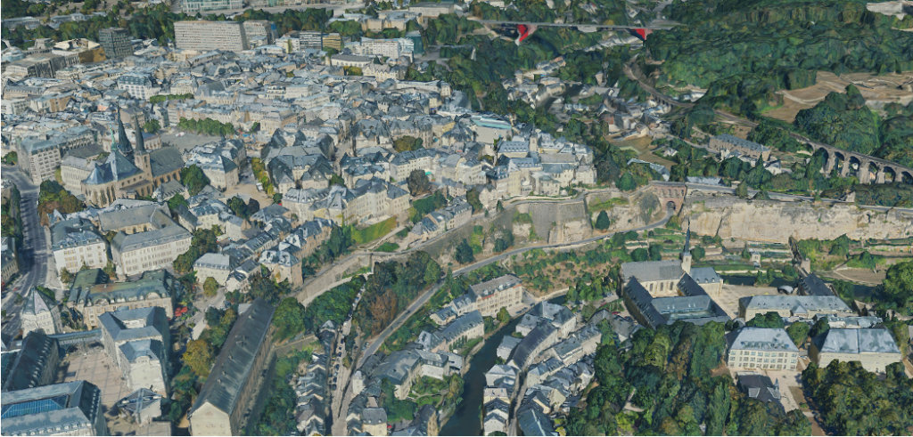
In a groundbreaking move towards comprehensive data representation, the Luxembourgish Geoportal has expanded its services from traditional two-dimensional maps to an immersive three-dimensional model. The meticulous creation of this 3D model involved the precise measurement of Luxembourg from above, capturing 82 billion reference points that define every tree, building, and street in the Grand Duchy. The extensive data collection for the 3D model included aerial imagery, ground elevation, and detailed information about buildings and vegetation.
The general dataset within Geoportail.lu forms the basis for various thematic sections, covering topics such as water management, agriculture, energy, and the recently introduced section dedicated to nature parks. The digital platform proves instrumental in the effective management of nature parks, allowing stakeholders to access pertinent information effortlessly. For instance, those engaged in agriculture can utilise the platform to streamline data retrieval, consequently reducing delays in negotiations related to the management of these critical natural areas.
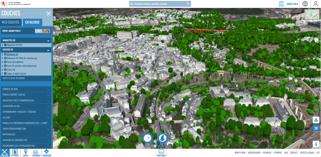
The platform’s significance extends beyond nature conservation, reaching into the realm of spatial planning and policy advice. The Geoportal can simplify complex decision-making processes in the development and sustainability of Luxembourg’s landscape, e.g. aiding in the identification of optimal locations for tree planting, particularly crucial in mitigating the impact of rising heatwaves. With a substantial user base of around 5,000 daily visitors, Geoportail.lu is a helpful tool, catering to the diverse needs of individuals, governmental ministries, and local administrations.
Moreover, the integration of the 3D model into the Geoportal serves as a powerful tool for urbanism, offering urban planners and architects a nuanced understanding of spatial dynamics. This enhanced spatial insight aids in optimising city layouts, infrastructure development, and the creation of more sustainable and liveable urban environments. It can also act as a catalyst for fostering collaborative initiatives. Through facilitating stakeholder engagement, the model allows urban planners, policymakers, and community members to collaboratively envision and refine development projects.
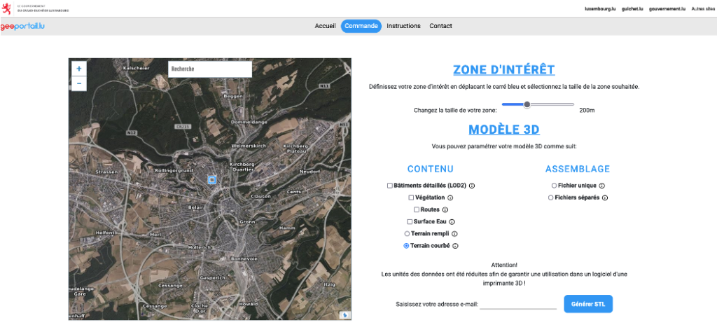
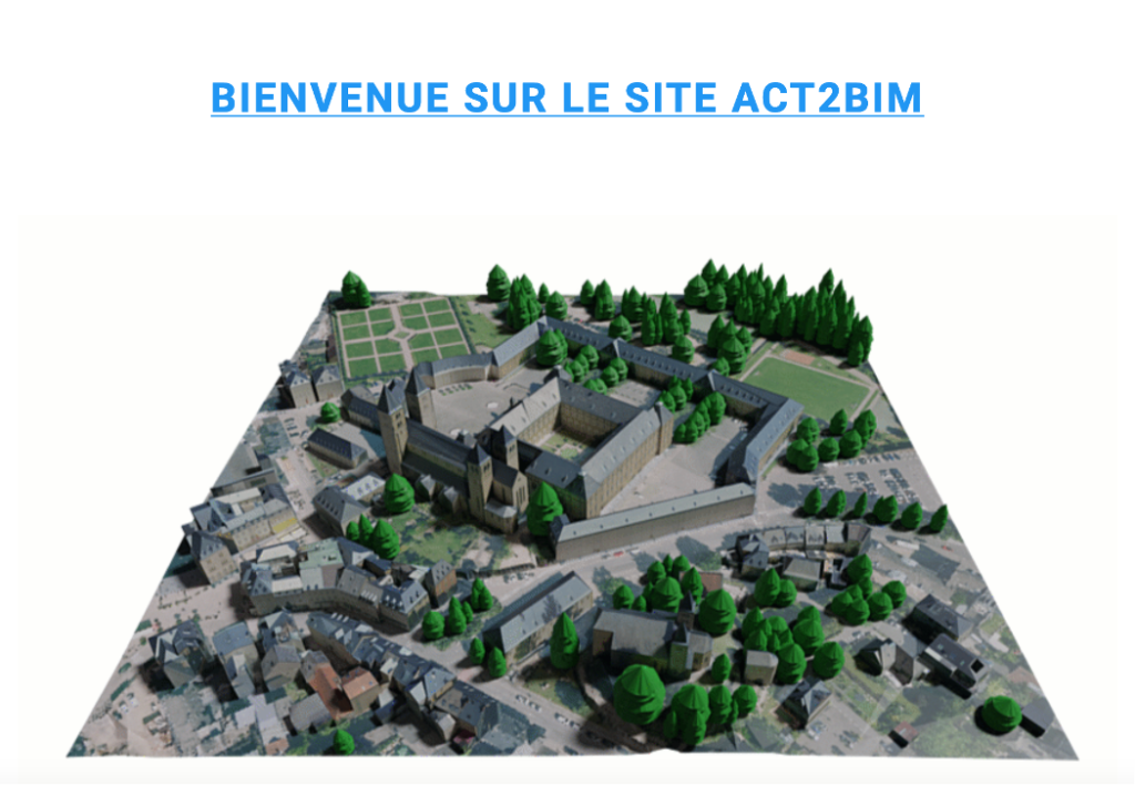
For those interested in specific data details, the Digital Building Luxembourg website (see below) provides further insights into the creation process of the 3D model. Additionally, the OpenData portal of the State (see below) offers downloadable files and resources related to the 3D model, including terrain models and surface models that can be printed in 3D or utilised in professional drawing or rendering software. The Administration du Cadastre et de la Topographie (see below) offers a detailed breakdown of available formats, use cases, and specific data sources, ensuring transparency and credibility in the utilisation of 3D geospatial information. Adding to this, the act2bim.geoportail.lu, a platform where georeferenced or local 3D files in Collada, IFC, or Sketchup formats can be ordered is set to launch end of January 2024.
The integration of the 3D model into the Geoportal not only elevates the user experience by offering a more immersive representation of Luxembourg’s landscape but also significantly enhances the platform’s utility across various sectors. This advanced spatial visualisation proves invaluable for urban planning and architectural simulations, providing a three-dimensional perspective that aids in optimising spatial development. Additionally, the 3D model enriches the Geoportal’s functionality for environmental conservation, allowing conservationists and policymakers to make more informed decisions regarding biodiversity preservation and sustainable land use. The synergistic integration of the 3D model into the Geoportal underscores its role as a dynamic and comprehensive tool, fostering improved decision-making processes and contributing to the holistic understanding of Luxembourg’s diverse terrain.
Contact
Geoportail: support@geoportail.lu
Digital Building Luxembourg: contact@crtib.lu
CIPU: cipu@zeyenbaumann.lu
References and further information
National Geoportail of the Grand-Duchy Luxembourg: https://www.geoportail.lu/en/
Digital Building Luxembourg website (FR): https://www.digitalbuilding.lu/fr/actualite/maquette-3d-du-territoire-national-luxembourgeois/
OpenData portal of the State: https://data.public.lu/
3D Print Export generation: https://3dprint.geoportail.lu/
Administration du Cadastre et de la Topographie: https://act.public.lu/fr/cartographie/export-print-3d.html