


Ressources
FR – Pour les villes et communes au Luxembourg
Comme plateforme d’information et d’échange pour les acteurs urbains à tous les niveaux, la CIPU soutient la collaboration, l’échange de connaissances et le renforcement des capacités dans le domaine du développement urbain. À cet effet, elle met à disposition une sélection de ressources utiles pour les villes et communes luxembourgeoises. Inspirez-vous des questions proposées afin d’identifier les ressources qui répondent le mieux à vos besoins.
EN – For (English-speaking) visitors
As an information and exchange platform, the CIPU also provides an overview of urban policy in Luxembourg, structured around key strategies and actors.
Pour les villes et communes au Luxembourg
Recensement des aides financières et subventions établi par le SYVICOL
Le SVICOL (Syndicat des Villes et Communes luxembourgeoises) a établi un recensement complet des aides financières et subventions nationales et européennes destinées aux communes luxembourgeoises.
Portail des Fonds européens du Grand-Duché de Luxembourg
Le Portail des Fonds européens présente les différents fonds européens et leurs programmes, et fournit des informations sur les modalités de participation, les appels à projets et les événements.
- Découvrez les fonds européens et leurs programmes au Luxembourg
- Inscrivez-vous à la newsletter des Fonds européens au Luxembourg
Les programmes de la Coopération territoriale européenne (« Interreg ») au Luxembourg
La brochure intitulée « Participer aux programmes Interreg en tant que commune (période 2021-2027) » fournit des informations utiles aux communes et présente les Points de contact au Luxembourg.
Urban Data Platform
La « Plateforme des données urbaines » (Urban Data Platform), géré par le Centre commun de recherche de la Commission européenne, met à disposition des cartes, des données, des tableaux de bord et des outils dans le domaine du développement urbain durable.
- Découvrez la fonction « My City » et explorez les indicateurs comparables des communes en Europe
- Découvrez les cartes interactives de la Plateforme des données urbaines
EUROSTAT
L’Office statistique de l’Union européenne (EUROSTAT) produit des statistiques et des analyses sur les villes européennes.
- Découvrez la section dédiée aux régions et villes européennes
- Découvrez la publication « Urban Europe » sur les statistiques urbaines
Portail interactif d’ESPON
Le programme ESPON gère un portail interactif qui met à disposition des cartes interactives, des données, des tableaux de bord et des applications dans le domaine du développement territorial en Europe.
- Découvrez les cartes interactives d’ESPON
- Découvrez les données, les tableaux de bord et les applications d’ESPON
Base de données KEEP
La base de données KEEP, gérée par le programme Interact, met à disposition des informations sur les projets des programmes de la Coopération territoriale européenne (« Interreg ») pour les périodes 2000-2006, 2007-2013, 2014-2020 et 2021-2027.
Base données Kohesio
La base de données Kohesio, gérée par la Direction générale de la politique régionale et urbaine de la Commission européenne, met à disposition des informations sur les projets cofinancés par les programmes de la politique de cohésion (FEDER, FSE, FC) à travers l’Europe pour la période 2014-2020.
Programme URBACT
URBACT est un programme de coopération territoriale européenne (« Interreg ») qui vise à promouvoir le développement urbain durable intégré dans les villes européennes en facilitant l’échange d’expériences et le transfert de bonnes pratiques par le biais de réseaux transnationaux. La « méthode URBACT » repose sur une approche intégrée et une participation de tous les acteurs.
- Recherchez une bonne pratique dans le catalogue d’URBACT
- Découvrez la boîte à outils dédiée à la « méthode URBACT »
- Découvrez les résultats et le savoir-faire d’URBACT
- Inscrivez à la newsletter du Point URBACT national « France et Luxembourg »
- Contactez le Point URBACT national « France et Luxembourg »
European Urban Initiative (EUI)
L’Initiative urbaine européenne (European Urban Initiative, EUI) est une initiative financée par l’Union européenne qui vise à soutenir les villes européennes à renforcer leurs capacités et leurs connaissances, à encourager l’innovation et à développer des solutions transférables face aux défis urbains. L’Initiative urbaine européenne gère également la plateforme Portico, point d’accès central à l’apprentissage urbain.
- Recherchez une action innovante dans le catalogue d’EUI
- Participez aux évaluations par les pairs (« Peer reviews »)
- Participez aux échanges de ville à ville (« City-to-City exchanges »)
- Explorez le « Urban Panorama » sur les programmes, initiatives, réseaux et organisations européens dédiés au développement urbain
Interreg Europe
Interreg Europe est un programme de coopération territoriale européenne (« Interreg ») qui vise à soutenir les autorités publiques européennes dans l’amélioration de leurs politiques régionales à travers l’échange d’expériences et le transfert de bonnes pratiques. Interreg Europe gère également la « Policy Learning Platform ».
- Recherchez une solution dans le catalogue d’Interreg Europe
- Participez aux évaluations par les pairs (« Peer reviews »)
- Participez à une session de mise en relation (« Matchmaking session »)
- Inscrivez à la newsletter du programme Interreg Europe
- Contactez le Point de contact Interreg Europe au Luxembourg
Programme ESPON
ESPON est un programme de coopération territoriale européenne (« Interreg ») qui produit des données, des analyses et des outils pour fournir de nouvelles connaissances sur les tendances territoriales et soutenir l’élaboration de politiques territoriales dans les villes et régions en Europe.
« Nouvelle Charte de Leipzig »
La « Nouvelle Charte de Leipzig » (New Leipzig Charter) a été adoptée le 30 novembre 2020 lors de la réunion informelle des ministres en charge de la politique urbaine sous la présidence allemande. Cette déclaration politique établit un cadre pour le développement urbain durable en Europe.
Elle définit cinq principes de bonne gouvernance urbaine, appliqués aux dimensions juste, verte, productive et numérique de la ville, à l’échelle du quartier, de l’autorité locale et de l’aire urbaine fonctionnelle. Sa mise en œuvre repose sur les politiques urbaines européennes et nationales et s’inscrit dans le renouvellement de l’Agenda urbain pour l’Union européenne, établi par le Pacte d’Amsterdam en 2016.
« Agenda urbain pour l’Union européenne »
Le « Pacte d’Amsterdam » (Pact of Amsterdam) est une déclaration politique adoptée le 30 mai 2016 lors de la réunion informelle des ministres en charge de la politique urbaine sous la présidence néerlandaise. Ce pacte établit « l’Agenda urbain pour l’Union européenne » (Urban Agenda for the EU) et définit les principes d’une coopération multiniveaux entre les États membres, les villes, la Commission européenne et d’autres parties prenantes.
L’Agenda urbain vise à mieux intégrer la dimension urbaine dans les politiques européennes en mettant en place des partenariats thématiques. Ceux-ci ont pour objectif d’améliorer la réglementation, les financements ainsi que la production et l’échange de connaissances sur les enjeux urbains, afin de mieux répondre aux défis spécifiques des villes en Europe.
« Nouveau Bauhaus européen »
À travers l’initiative interdisciplinaire et créative du « Nouveau Bauhaus européen » (New European Bauhaus), l’Union européenne exprime son ambition de promouvoir la durabilité, l’inclusion et l’esthétique dans l’environnement bâti, les produits et les modes de vie. S’inscrivant dans le cadre de la transition verte, l’accent est mis sur l’innovation, la circularité, l’utilisation de matériaux biosourcés et le logement abordable, tout en respectant la diversité des lieux et en renforçant le sentiment d’appartenance.
L’initiative est mise en œuvre en partie à travers l’instrument « NEB Facility », dont l’objectif est de développer et tester des solutions innovantes pour la revitalisation des quartiers (composante « R&I ») ainsi que de généraliser et déployer des solutions dont la valeur ajoutée a déjà été démontrée (composante « roll-out »).
Niveau mondial
En complément du cadre européen de la politique urbaine, le « Nouvel Agenda Urbain », adopté le 20 octobre 2016 lors de la Conférence HABITAT III à Quito, et les « Principes de politique urbaine de l’OCDE », adoptés le 19 mars 2019 lors de la 7e Table ronde des maires et des ministres de l’OCDE à Athènes, fournissent des orientations internationales pour des villes justes, sûres, saines, accessibles, abordables, résilientes et durables.
For visitors: Urban policy in Luxembourg
The national urban policy of Luxembourg is defined by the « Master Programme for Spatial Planning » (Programme directeur d’aménagement du territoire – PDAT).
The national urban policy of Luxembourg is defined by the « Master Programme for Spatial Planning » (Programme directeur d’aménagement du territoire – PDAT), which was adopted by the Government in 2023, and is currently in its implementation phase. The PDAT is fully aligned with the principles of the New Leipzig Charter and contributes to the implementation of the Sustainable Development Goal 11.
(Source: PDAT pages 16-25, 103-104)
The Master Programme for Spatial Planning is one of the main instruments of spatial planning policy in the Grand Duchy of Luxembourg and provides a framework for its territorial development. Its role is to provide political objectives and strategic guidelines to support the actors involved in spatial planning and coordinate inter-sectoral action between the governmental and municipal authorities which has an impact on Luxembourg’s territory.
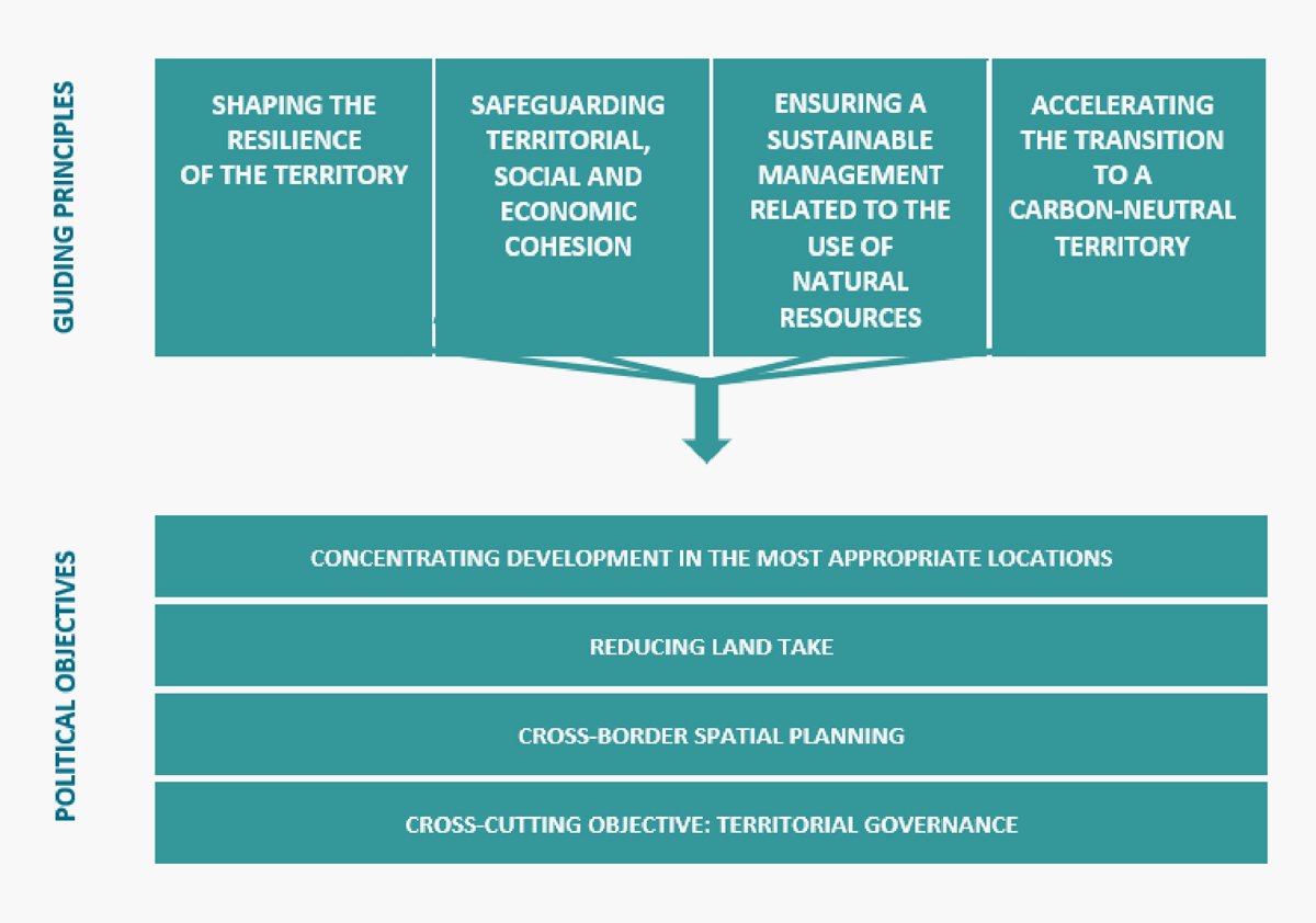
The PDAT defines three political objectives and one cross-cutting objective. Their definition was shaped by four guiding principles for spatial planning whose aim is to further the ecological transition of Luxembourg’s territory.
(Source: PDAT pages 40-57)
In order to implement the political objectives, the Master Programme defines an urban system based on “Central Places” (Centres de développement et d’attraction – CDA) and a typology of territories.
The urban system is meant to guide territorial development at the national level and identifies:
- three urban agglomerations incorporating “Central Places” of European, national and regional importance
- eleven “Central Places” of regional importance outside of the urban agglomerations
- municipalities with endogenous development

The three urban agglomerations include:
- Agglo-Centre (Central Agglomeration): Large agglomeration around the capital city, incorporating the City of Luxembourg (as a CDA of European importance)
- Région Sud (Southern Region): Polycentric agglomeration in the south of the country, incorporating the City of Esch-sur-Alzette (as a CDA of national importance), the City of Differdange (as a CDA of regional importance) and the City of Dudelange (as a CDA of regional importance)
- Nordstad (Northern Agglomeration): Tripolar agglomeration in the north of the country, incorporating the City of Diekirch, the City of Ettelbruck and the Municipality of Erpeldange-sur-Sûre (as a single CDA of national importance)
These urban agglomerations can cover urban and suburban territories, as they follow the continuous urban fabric beyond municipal boundaries. They are primarily destined for the development of housing, economic activities and public facilities, concentrating a significant proportion of the country’s growth potential for population and jobs.
(Source: PDAT pages 68-73, 162-176)
The three urban agglomerations also form the core of functional urban areas called “Urban and Suburban Action Areas” (Espaces d’action urbains et périurbains):
- Espace d’action de l’Agglo-Centre (Action area of the Central Agglomeration)
- Espace d’action de la Région Sud (Action area of the Southern Region)
- Espace d’action de la Nordstad (Action area of the Northern Agglomeration)
For these urban and suburban action areas, territorial visions were developed to guide their long-term territorial development.
(Source: PDAT pages 148-150, 162-176)
On the basis of the political objectives, the Master Programme sets a national territorial development strategy, which is broken down to take into account the specific characteristics of urban, suburban and rural territories.
During the development of territorial visions for the three action areas of the Nordstad, the Agglo-Centre, and the Région Sud, five major challenges were identified for urban territories:
- Preparing urban and suburban territories for the effects of climate change by preserving, restoring and improving the municipal and intermunicipal networks of green and blue infrastructure;
- Redeveloping monofunctional areas, large-scale sealed areas and industrial brownfields, as well as prioritising urban regeneration in order to reduce pressure on undeveloped land and green spaces;
- Further developing the public transport network and promoting active mobility;
- Reconsidering urban structures by emphasising the complementarities and mix of functions in order to reduce the need for travel;
- Defining the right balance between the protection and the use of green spaces, particularly for leisure activities.
(Source: PDAT page 162)
The territorial development strategy for urban territories takes up these challenges and identifies several guiding principles for urban development:
1. Safeguarding the quality of public spaces and implementing the concept of the 15-minute-city by:
- Maintaining a well-connected, safe, and human-centred continuity of public spaces.
- Developing a comprehensive greening strategy for public spaces while fostering nature-based solutions
- Improving the accessibility of public services and infrastructure through the promotion of public transport and active mobility.
- Encouraging multifunctionality across all spatial scales.
- Establishing a new planning culture rooted in co-design and participation
2. Safeguarding quality of life in dense urban areas by:
- Welcoming nature into the city by establishing and preserving green belts around the urban agglomerations, enhancing the connectivity of green and blue infrastructure to create an integrated ecological network, promoting nature-related experiences, and incorporating the cooling principle into urban development
- Acknowledging the vital role of quiet areas in and around urban agglomerations.
- Encouraging physical activity and sports for people of all genders, ages, and abilities by integrating the principle of “active design” into urban development.
The concrete implementation of these guiding principles at the level of a new neighbourhood is illustrated in the Planungshandbuch (Planning Handbook).
(Source: PDAT pages 96-101)
The PDAT also sets out measures for implementing its political objectives, strategies and guiding principles:
URBAN CLIMATE
- Prepare heavily sealed or impervious areas to cope with the effects of climate change, including heat waves, intense precipitation and flooding.
- Encourage climate-sensitive urban development that reduces urban heat islands and limits excessive soil sealing.
- Promote energy production from renewable sources.
- Reduce emissions from individual motorised transport.
URBAN MOBILITY
- Strive towards the ’15-minute city’ model and promote the adoption of active mobility solutions.
- Establish a coherent parking management strategy that incorporates active mobility solutions.
- Reduce on-street vehicle parking to reallocate public space in favour of pedestrians and cyclists.
- Pursue the expansion and optimisation of the public transport network.
- Design context-specific mobility strategies for suburban territories.
URBAN GROWTH MANAGEMENT
- Achieve a better balance between the number of jobs and the number residents.
- Manage demographic and economic growth in a way that preserves quality of life and limits land take.
- Ensure the supply of drinking water through regional cooperation between drinking water providers and drinking water associations.
- Limit noise, air and light pollution and prevent their impacts on public health.
URBAN DEVELOPMENT
- Restructure spatial organisation to curb urban sprawl and reduce land take.
- Support social diversity by ensuring access to affordable and differentiated housing types.
- Strive for more sustained and high-quality urban regeneration.
- Promote multifunctional and mixed-use development in strategically located and suitable areas
NATURE IN THE CITY
- Develop an ecological network across the urban agglomeration and improve access to green spaces in the city.
- Reconnect people with nature through urban farming, pocket parks and other nature-based experiences in the city.
- Promote local food production, while enhancing biodiversity in the city.
- Bring nature back into the city through green corridors, roofs and façades.
- Restore and renaturalise urban watercourses.
SOCIAL COHESION IN THE CITY
- Ensure access to affordable housing for disadvantaged households.
- Promote the development and maintenance of inclusive, multifunctional and safe public spaces of high quality.
- Encourage the development of a sharing economy.
- Create spaces for community interaction, such as third places.
(Source: PDAT page 163)
Two instruments for implementing the national urban policy are the Cellule nationale d’Information pour la Politique Urbaine (National Information Unit for Urban Policy) and the Planungshandbuch (Planning Handbook).
Another instrument are the Conventions of territorial cooperation between the State and municipalities, which promote inter-municipal and multi-level cooperation in order to foster sustainable regional development, encourage integrated planning and address specific development issues in urban, suburban or rural territories. These conventions are voluntary agreements between the Department of Spatial Planning (and potentially other national authorities) and several municipalities (or an inter-municipal association), with an organisational structure and a financial framework.
(Source: PDAT pages 108-109, 115)
The following actors play a role in the definition, design and implementation of urban policy in Luxembourg. This is a non-exhaustive list that can be expanded as needed.
- Département de l’aménagement du territoire du Ministère du Logement et de l’Aménagement du territoire
(Department of Spatial Planning of the Ministry of Housing and Spatial Planning – responsible for spatial planning policy as well as national and European urban policy)
Spatial planning Portal - Département du logement du Ministère du Logement et de l’Aménagement du territoire
(Department of Housing of the Ministry of Housing and Spatial Planning – responsible for housing policy)
Housing Portal - Ministère des Affaires intérieures
(Ministry of Home Affairs – responsible for urban planning and development policy as well as the administrative oversight of municipalities)
Urban planning website - Ministère de l’Environnement, du Climat et de la Biodiversité
(Ministry of the Environment, Climate and Biodiversity – responsible for environmental and climate policy) Environment Portal - Ministère de la Mobilité et des Travaux publics
(Ministry of Mobility and Public Works – responsible for transport policy and public works)
Transport Portal and Public works Portal - Ministère de la Culture
(Ministry of Culture – responsible for architectural policy and Baukultur as well as cultural heritage)
- Administration de l’environnement
(Environment Agency) - Administration de la gestion de l’eau
(Water Management Agency) - Administration de la nature et des forêts
(Nature and Forest Agency) - Administration des bâtiments publics
(Public Buildings Administration) - Administration des ponts et chaussées
(National Roads and Bridges Administration) - Administration du cadastre et de la topographie
(Land Registry and Topography Administration) - Cellule de facilitation urbanisme et environnement
(Facilitation Unit for Urban Planning and Environment) - Klima-Agence
- STATEC – Institut national de la statistique et des études économiques
(STATEC – National Institute of statistics and economic studies)
- Syndicat des Villes & Communes luxembourgeoises
(Association of Luxembourgish Cities and Municipalities) - List of all 100 municipalities
- List of all inter-municipal associations
- Inter-municipal association NORDSTAD
- Inter-municipal association PRO-SUD
- OAI – Ordre des Architectes et des Ingénieurs-Conseils
(OAI – Order of Architects and Engineers) - LUCA – Luxembourg Center for Architecture
- AULA – Aménageurs et Urbanistes du Luxembourg
(AULA – Spatial and Urban Planners of Luxembourg)